

The Red Centre is a place that's both at the heart of Australia and deep in the hearts of Australians. It's here that Uluru sits at the country's nucleus, where parallel red sand dunes run like ribs across the country, and where vastness goes from a concept to a reality.
Circling through this evocative area is the Red Centre Way, one of Australia's great driving routes, looping out from Alice Springs past extraordinary natural features and hidden wonders alike. Feel the desert weave its charms on you before washing it all away with a swim in one of the Red Centre's many waterholes.
It's recommended that you travel by 4WD, as much of the route is unsealed.


"Kata Tjutu, Uluru's amazing sibling(s)" — Photo Credit: Shutter stock

Alice Springs Desert Park
Get perspective on the journey ahead with a visit to the Alice Springs Desert Park, just six kilometres outside of Alice Springs as you leave town on Larapinta Drive. The park is like a field guide to the country that awaits you, featuring three carefully designed desert habitats: sand country, woodland and desert rivers. You'll discover the flora and curious fauna of the Red Centre, as the park is involved in breeding programmes and conservation of endangered species and ecosystems of the area, so it’s a great place to visit and learn.
There's also a bird of prey show and even guided nocturnal tours if you really want to know what's making all those noises outside your room or tent at night.

1
Simpsons Gap
The West MacDonnell Ranges, aka the West Macs, point due west from Alice Springs and are one of the Red Centre's standout natural features. One of the world's oldest mountain ranges, they're split by a series of gaps and gorges, and the first of these outside of Alice is the gorgeous Simpsons Gap. From the car park it's a short walk to the mouth of the gap, and if you come at dawn or dusk this is the most reliable place in the area to try to spot black-footed rock wallabies. They're elusive, but scan the boulders and red cliffs that enclose the waterhole and they might just be peering back.

The quintessential piece of the West Macs, Standley Chasm is a narrow cleft in the range that creates a daily light spectacular. From the car park, it's about a 20-minute walk along a rocky creek bed to the chasm entrance. Inside, it'll feel almost as though you can stretch out your arms and touch both walls. The best time to be here is an hour either side of noon on a sunny day (which is pretty standard here), when reflected sunlight causes the chasm to light up like golden stained glass.

Feeling the heat yet? Pull into Ellery Creek Big Hole, around 50 kilometres west of Standley Chasm along Larapinta Drive, and wade into one of the largest waterholes along the West MacDonnell Ranges. The reed-fringed waterhole is pooled outside the entrance to another gap in the range. Brace yourself - the most surprising thing here (and along all West Mac waterholes) is the chill. Only the hardiest souls will be lounging around in this water for hours, but it's beautifully inviting for a quick dip.

Serpentine Chalet Dam
See a gap with a difference by stretching your legs on a walk into Inarlanga Pass. From Serpentine Gorge, it's a short walk up to the site of a dam constructed for the first resort - a dismal failure - built along the West Macs. You can swim here (have a look for frogs on the cliffs around the base of the waterfall), but it's also little more than a two-kilometre walk along the range's foot from here into Inarlanga Pass. Unlike other water-filled gaps, this one is dry and brimming with cycads, a fern-like plant that remembers the dinosaurs - cycads have been on Earth for more than 200 million years.

3
Ochre Pits
Just a few kilometres beyond Serpentine Gorge is a bend in a creek bed known as the Ochre Pits. Here, local Arrernte people have long gathered ochre for ceremonial use and for trade with other Aboriginal people. A short walk leads to the creek with its high bank of ochre cliffs, which are an ice-cream-like swirl of colours - yellow, purple, white. Guides are available and they will talk you through the history and stories of this sacred place.

As the West Macs near their western end, they're suddenly split by the largest and most impressive of the ranges' gorges. Ormiston Gorge writhes through the mountains in a classic outback scene of ghost gums, red rock and ephemeral waterholes. To get the full sense of the gorge, walk the 7.5-kilometre loop trail through the gorge and Ormiston Pound, or the shorter Ghost Gum Walk, climbing to a lookout platform (beside the eponymous ghost gum) that peers straight through the guts of the gorge. The large waterhole in the cliff-lined river bend beside the car park is one of the region's most popular swimming spots. The camp grounds and kiosk at the campgrounds are great places to stop, as the facilities are clean and well priced, the food and coffee is good, and the couple who run them both are super friendly and helpful.

Almost directly across Larapinta Drive from Ormiston Gorge, the mountains seem almost to have snapped to create Glen Helen Gorge. The waterhole inside the break is another fine swimming pool.

6
Glen Helen Homestead Lodge
And the adjoining Glen Helen Homestead Lodge provides the only hotel-style accommodation along the entire line of the West MacDonnell Ranges. There are motel-style rooms, the classic outback experience of the stockmen quarters, camping and a restaurant and bar with an outdoor terrace peering onto the red rock walls that enclose the gorge.

Starting point for your journey up the magnificent Mount Sonder.

Mount Sonder
The West Macs end in a shapely blaze of glory atop Mt Sonder, known to local Aboriginal people as the 'Sleeping Woman', (the reasons will become obvious from its profile) and immortalised in a number of paintings by famed Aboriginal artist Albert Namatjira. You'll see Sonder along the drive, but it's best experienced by climbing it - about a six-hour return walk from Redbank Gorge. The view from the top takes in the straight lines of the West Macs, Glen Helen Gorge and Gosse Bluff crater. Tradition is to hike through the night for a truly spectacular sunrise from Sonder's summit.

8
Gosse Bluff
As the Red Centre Way veers south and away from the West Macs, you'll come to a turning to one of Australia's most curious mountain 'ranges'. Gosse Bluff (Tornala to the local Arrernte people) sits like a beauty spot in the desert, and is a circle of hills thought to have been created by the rippled impact of a meteorite striking Earth around 140 million years ago. There are a couple of short walks here that provide good perspective on the crater, though please note that it's an Aboriginal sacred site and access inside the crater and to the rim is restricted.

9
Hermannsburg Potters
Detour back east around 50 kilometres and you'll come to Hermannsburg, an Aboriginal community that was established as a Lutheran mission in the 1880s. Today you can wander around the Hermannsburg Historical Precinct with its whitewashed buildings and church. Hermannsburg was the birthplace of landscape painter Albert Namatjira, arguably the most famous of all Aboriginal artists. The Namatjira Gallery displays original paintings by the artist and his family, as well as terracotta works from famed Hermannsburg Potters.

If you're travelling in a 4WD vehicle, head south from Hermannsburg into Finke Gorge National Park, following rocky tracks beside one of the world's oldest rivers to Palm Valley. Filling the valley (actually a gorge) is a remnant stand of rainforest brimming with thousands of red cabbage palms that can grow up to 25 metres in height. These palms are found nowhere else in the world except Palm Valley. Two walking trails - the hour-long Arankaia Walk, and two-hour Mpulungkinya Walk - circuit through the valley.

11
Kings Canyon
Turning back west, the Red Centre Way journeys through beautifully nondescript desert lands to reach Kings Canyon, a massive natural amphitheatre framed with rust-coloured 100-metre-high cliffs. If you want the full wow factor, take a helicopter flight over the canyon; otherwise hike the six-kilometre Canyon Rim Walk. This lingering look over the edge heads through the Lost City, where striped sandstone domes (think of a scale-model version of Western Australia's famed Bungles Bungles) rise from the earth, and a lush, shaded oasis known as the Garden of Eden is situated. This is especially picturesque if you come after rain as its waterfalls may even be flowing. Kings Canyon Resort offers accommodation and camping.

12
Mount Conner
As you drive south from Kings Canyon, you'll spy a flat-topped red mountain that so many people mistake for Uluru - some locals even call it Fool-uru. Mt Conner stands at a similar height above the sands as Uluru, but there the comparisons realistically end. Mt Conner is millions of years older than Uluru with a classic mesa (tabletop) shape to Uluru's rounded figure. You'll come to a Mt Conner lookout point beside the road about 20 kilometres before you reach Curtin Springs, but the mountain is on private land, so can only be accessed on tours out of Uluru or Curtin Springs.

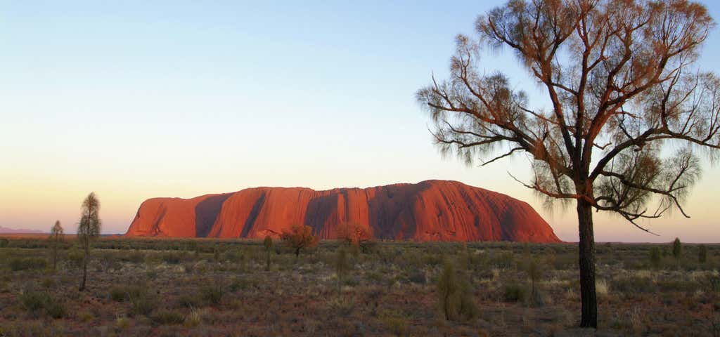
Australia's greatest rock star vies with the Great Barrier Reef for the title of the country's most famous natural attraction. Rising almost 350 metres from the sandy plain, it's as extraordinary as its reputation suggests. The local Anangu people request visitors not to climb Uluru, but there's plenty else here to keep you engaged with 'the Rock'. Drive to the sunrise and sunset viewing areas, walk the 9.5-kilometre loop around Uluru's base or hire a bike and pedal the same path.
And at sunset make sure you take in the unbelievably good Field of Light show at Pitjantjatjara, by artist Bruce Munro. Covering more than seven football fields, with 50,000 spindles of light the breathing swaying mass of stems make up a fantasy garden that Alice and the Mad Hatter would feel right at home in. It’s on until 2020.

Another option is to take a shorter stroll into Mutitjulu waterhole, tucked into the base of the Rock. In the evening, join a Sounds of Silence dinner and start with canapés in view of Uluru before dinner beneath more stars than you probably knew existed.

Uluru's marginally less famous sibling is this jumble of giant rocks, 50 kilometres' drive to the west. The name of the 36 bulbous domes means 'many heads' and they're at least as spectacular as Uluru itself - the tallest rock here is around 200 metres higher than Uluru.
And the finest way to see and experience Kata Tjuta is by spending a few hours on the Valley of the Winds walk, a 7.4-kilometre trail that weaves through the domes and the gorges that separate them.
Explore More Trip Guides
- Trip Guide
Outback Way
- 23 Places
- 54:10
- 2,360 mi
- Trip Guide
The Nullarbor
- 20 Places
- 24:56
- 1,063 mi
- Trip Guide
Sydney To Melbourne Coastal Drive
- 28 Places
- 29:32
- 1,063 mi
- Trip Guide
Exploring the paradise that is Fraser Island
- 10 Places