

With such a mighty river raging through the Waikato (the longest river in New Zealand) the Waikato region has some fine walks to explore, and many have waterfalls. Here are 14 of the best.
Remember, before embarking on any walk: plan your trip, check the weather, tell someone where you're going and take gear including water, food, warm clothing, jacket, torch, basic first aid kit and a map of where you're walking. To ensure you have an awesome adventure, check out these interactive guides from the NZ Mountain Safety Council.

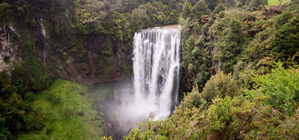
Omaru Falls Walk
1.7 km return via same track.
Cross the stile and walk across the farm track for a few hundred metres. There is another stile to cross before the walking track enters bush filled with ferns and young rimu. The track follows a stream before crossing a swing bridge and back onto farmland. Follow the grassy track and orange markers. There is an ideal picnic spot next to the river and a small terraced waterfall.
Continue up the grassy track to the falls lookout. The falls drop about 45 m and are most impressive after times of heavy rain.
Getting there: 12 km south of Te Kuiti, turn left at the Taumaranui/National Park turnoff on to SH 4. Go down SH4 for 19 km then turn off at Omaru Road. The turnoff is located on the right hand side of the road and is clearly signposted. The Omaru Falls car park and track entrance is 500 m down Omaru Road.

Wairēinga/Bridal Veil Falls Walk
Waireinga Falls is one of the North Island's most popular spots for popping the question with its 55 metre curtain of water and stunning pool at the base that looks like something out of Neverland. And if you're lucky you might spot some schmuck down on one knee.
Car park to top of falls Time: 10 min one way Top of falls to base of falls Time: 10 min one way
It is an attractive easy walk through native forest following the Pakoka River to the top of the Waireinga/Bridal Veil Falls. This section is designed for assisted wheelchairs or children’s buggies so everyone gets a look in.
The two viewing platforms at the top have epic views of the falls and countryside. From here, the track goes steeply down stairs to a midway viewpoint, then continues down more stairs to the bottom view bridge and information shelter with still more mouth dropping views across the pool and up at the falls.
Getting there: Access is via Te Mata Road off the Hamilton/Raglan Highway (SH23). Turn left into Kawhia Road, 1 km past Te Mata and travel another 4 km to the car park.
Nature and conservation: Rocks around the pool are mainly soft sandstones that have been worn down by the river to form a large amphitheatre. If you look up from the base of the falls, you can see the band of hard basalt rock (which came from a volcano about 1.5 km away) that has resisted the erosive power of the water and now forms the lip of the falls.
Know before you go: Please don't go swimming - water quality here does not meet health standards. And to protect endangered plants, please no abseiling or rock climbing.
But as for marriage proposals - go for gold! (But if you want our advice find somewhere else that is special but not so well known.)

Spa Park to Huka Falls Walk
Time: 1 hr 30 min Distance: 3 km
This walking track allows you to walk rather than drive to the Huka Falls from Taupo. It's a pleasant walk for the whole family, starting from Spa Park and winding along the banks of the Waikato River.
From the car park walk five minutes down to the river's edge where you'll cross the Otumuheke Stream, a naturally hot stream which flows into the Waikato. The well-defined track then continues along the riverbank and offers lovely views along the way.
Return via the same track or arrange transport from Huka Falls carpark.
For a longer walk, continue from Huka Falls along the Aratiatia Rapids Track. This track is for walkers only, so to mountain bike from Spa Park to Huka Falls take the Rotary Ride.
Getting there: For Spa Park, turn right off Tongariro Street into Spa Road at the northern end of Taupo, then left into County Avenue and drive into Spa Thermal Park.
Helpful hints: Volunteers from the Craters of the Moon Trust have assisted with the management of the Huka Falls since 2000. Visitors are given a warm welcome from local volunteers who run the information kiosk, where you can buy refreshments or use the toilets for 50 cents. But please note that the car park is locked overnight from 6 pm - 8 am in summer (daylight savings), and 5:30 pm - 8 am in winter.

Mangapohue Natural Bridge
Mangapohue Natural Bridge is a highlight on the scenic drive from Waitomo Village to Marokopa. The track is pushchair-friendly and follows a boardwalk through an impressive limestone gorge that takes you underneath a natural bridge.
The 17 m high limestone arch, which spans the Mangapohue Stream, is all that remains of an ancient cave system. From here the track becomes stepped and passes under the bridge giving a superb view of the ceiling studded with stalactite-like formations and an excellent view back down the gorge.
The track continues for over farmland. Follow the marker posts around to the right and up the hill where you can see 25 million year old fossilised oysters exposed in the limestone outcrops. Follow the marker posts until you cross a stile back into the reserve heading back to the car park.
Combine this walk with Piripiri Cave Walk and Marokopa Falls Walk on a scenic drive from Waitomo to Marokopa.
Getting there The track starts on Te Anga Road, 25 km from Waitomo Village.

Kauri Loop Track
Kauri grove: Time: 40 min one way
This well formed track offers spectacular views, beautiful bush and one of the largest kauri trees in the Waikato.
The track starts with a flight of stairs, then levels out to cross a largely open face with views to the north. Walk past an old pa site (hidden by vegetation) through regenerating native bush to a large kauri tree, estimated to be over a thousand years old. A few minutes further on, and past the site of a large kauri that fell in 2009, the track passes through a grove of young kauri (rickers) to a viewpoint that looks out across the forest. Return the way you came or continue on to complete the full loop.
Full loop: Time: 2 hr
From the viewpoint, climb up through stands of large rimu to an excellent view point of Huntly and the north Waikato lakes. From here you can continue on the Hakarimata Walkway to the Southern Lookout (20 min, 700 m) with views that extend across Hamilton and south to Tongariro National Park on a clear day. Otherwise continue on the loop track, descend through an attractive grove of nikau palms to a lower viewpoint and the car park.
Getting there: The track is 6.9 km south of Huntly and 11.2 km north of Ngaruawahia. It starts from the end of Parker Road, off Hakarimata Road which connects these two towns.
PLEASE CONSIDER KAURI DIEBACK DISEASE AND MAKE SURE YOU CLEAN AND SCRUB YOUR SHOES BEFORE ENTERING THIS LOOP.

Kaniwhaniwha: Nikau Walk and Kaniwhaniwha Caves
Nikau Walk Walking time: 2 hr 30 min return Distance: 7 km
The track starts from the Kaniwhaniwha car park. It passes through a recently planted area, then follows along the stream to a loop walk, lush with nikau palms and tree ferns. There are opportunities for swimming and picnicking along the stream, and a picnic/campsite with toilets is a short distance off the track (this is accessible by wheelchair, but the loop track is not). This walk can be combined with the Kaniwhaniwha Caves adding 30 minutes to the walking time.
Mountain biking: The track is ideal for family cycling but do follow directional signs around the loop track as this is a shared-use track. Follow the mountain bikers code: respect others, respect the rules, respect the track.
Kaniwhaniwha Caves Walking time: 2 hr 30 min return Distance: 7 km The two limestone caves are near the start of the Bell Track, 5 minutes from the junction with the Nikau Walk. You can walk through the 20 metre long main cave, but note there is a short hands-and-knees crawl. The cave is wet underfoot and torches are required. The second smaller cave is tight and narrow.
Getting there: These tracks are accessed from Limeworks Loop Road. From Hamilton take SH23 to Whatawhata. Turn left onto Te Pahu Road after the bridge over the Waipa River. Limeworks Loop Road is about 10.6 km on the right.

Hakarimata Summit Walk
2 km return via same track
Follow the Waterworks Walk to just before the dam where the track branches off to the right and climbs steeply up a well constructed set of steps and stairs. It is a 335 metre climb from Brownlee Avenue to the summit with 1349 steps!
The track meets the Hakarimata Walkway and the summit tower at 374 metres above sea level. In spring you can smell the scented daphne, Alseuosmia hakarimata or topara growing beside the track.
The tower provides good views out towards the coast andacross the Waikato Basin and down to Ruapehu on a clear day.
Getting there: The Hakarimata Summit Track is accessed via the Waterworks Walk. The Waterworks Walk starts on Brownlee Avenue, off Hakarimata Road, approx. 1 km north of Ngaruawahia.

Mangakara Nature Walk
Loop Track - 1 Hour
The walk meanders through an ancient forest, with large rimu, kahikatea, tawa, pukatea and kohekohe and takes you to the beautiful Mangakara Stream before looping back.
There are numbered posts at points of interest along the walk. There are also illustrated signs to further your understanding and appreciation of this special place. It's accessible to people of most ages and fitness levels but is not suitable for wheelchairs or pushchairs. (Seats are located around the walk.)
Getting there: The track starts 11 km north of Pirongia. 5.5 km north of Pirongia, turn off SH39 onto Te Pahu Road. Take the first left turn into Hodgson Road, then turn left turn into Grey Road and follow this to the end.

Waitomo Walkway
3.3 km - 1 hr 15 min one way
The walkway is an easy grade except for some short steep parts. It starts in the Waitomo Village (opposite the Discovery Centre) and passes up through bush and across farmland with some great views back to the Waitomo Village. It then crosses the Te Anga Road beyond the Waitomo Glowworm Caves. From here it follows the Waitomo Stream through a mix of shady forest and open farmland to the Ruakuri Scenic Reserve.
Nature and conservation: The Waitomo Walkway has a variety of limestone features to view. Dolines (enclosed depressions), karren (fluted outcrops), arches tunnels and caves are collectively known as karst. This special landscape is a feature of Waitomo, with the Waitomo Caves world famous for their beauty and abundance of glow worms. Along the banks of the Waitomo Stream you will see a major replanting project undertaken by the community, DOC and Environment Waikato to improve water quality and reduce the effect of erosion.
Know before you go: There are a number of sections along the walkway where you cross onto private land. Follow marker posts and use stiles where provided. Be aware of electric fences. In addition, the Waitomo Walkway can be prone to flooding in times of heavy rain. There is a small general store in Waitomo where supplies may be bought, but you must fill up your vehicle with fuel at Otorohanga, Piopio or Te Kuiti as there are no service stations from Waitomo west.

Ruakuri Bush Walk
Ruakuri Bushwalk, a 30 minute loop track, taking in some of the best examples of limestone formation including the 30m Ruakuri Natural Bridge.
There is parking, toilets, a picnic area as well as this is starting point for Aranui Cave. Camping not permitted.

Marokopa Waterfalls
The 35 m high falls are often described as the most beautiful in the country. Here the Marokopa River cascades over the undercut greywacke basement rock.
Take the short track (600m) through tawa and nikau forest down to the viewing platform.
Combine this walk with Mangapohue Natural Bridge Walk and Piripiri Cave Walk on a scenic drive from Waitomo to Marokopa.
Getting there Marokopa Falls is 15 km east of Marokopa and 31 km west of Waitomo, on Te Anga Road.

Huka Falls
The Huka Falls are the largest falls on the Waikato River, near Taupo on New Zealand's North Island. In fact, they are the most visited natural attraction in New Zealand.
The Waikato river is one of New Zealand's longest rivers and it drains Lake Taupo - the largest freshwater lake in all of Australasia. At Huka Falls, the Waikato River which is normally 100m wide, is squeezed through a 20 metre wide gorge and over a 20m drop. Every second up to 220,000 litres of water gushes through the gorge and shoots out over 8 metres beyond to create a beautful blue/green pool. The name Huka is the Maori word for 'foam', which is appropriate as the falling water and rapids certainly resembles foam, especially under flooding conditions.
Huka Falls is located in Wairakei Park. This is only a short 5 minute drive north of Lake Taupo. Or you can choose the 30 minute riverside walk as a way to get to the several viewing platforms that are available.

Aratiatia Rapids
Time: 10 min Distance: 620 m
The track leading to the two lookout points begins 50 metres from the bridge on the true right of the river. Before the water was diverted to the power station in 1964, the Aratiatia Rapids were the largest in Australasia - the Waikato River dropping 28 metres in just one kilometre. Today their full potential can still be seen during the scheduled daily releases. Each release lasts 15 minutes. Opening times: 10 am; 12 noon; 2 pm (and also 4 pm 1 October - 31 March)
The tiers of the rapids and steep walls of the gorge are remnants of an ancient volcano. It is said the the name "Aratiatia" comes from the meaning "stairway of Tia". Tia was a leader from the waka Te Arawa, and passed through the gorge with a small party on route to discovering Lake Taupo. These are also the famous rapids used in the filming of the barrel escape scene in Peter Jackson's movie, The Hobbit: The Desolation of Smaug.

Te Waihou Walkway
Maori for ‘the new water’ this area is also known as The Blue Spring and when you see the crystal clear water with your own two eyes, only then will you believe that it’s not been photo-shopped. Parking up at the Whites Rd car park off State Highway 28, this easy walking track follows the path of the Waihou River (complete with trout) and includes areas of native bush, farmland and pasture, wetlands and waterfalls whilst the river changes character along the way from wild to mild.
A pure delight from start to finish, the information panels along the way help to explain things about the history and ecology of the area. Fed from the Mamaku Plateau, the water you see here is said to take 100 years to filter down to this point, making it some of the purest water in the land which is why over 70% of New Zealand’s water is bottled here. Happily the area is still a pristine beauty spot - in spite of the industry that the water attracts. But don’t bother bringing your swimsuit because swimming is not allowed here in order to preserve the cleanliness of the water – and you probably wouldn’t want to take a dip anyway, given the water stays pretty close to 11 degrees all year round.
If you’re not free to walk for hours, you can cut the hike down to 30 minutes return by tackling the track from Leslie Rd - although if you do have time to spare - the longer walk is well advised because it’s just so astonishingly pretty.
Banner Photo Credit: Department Of Conservation
Explore More Trip Guides
- Trip Guide
Wellington's Best Walks
- 18 Places
- Trip Guide
West Coast Region Walks
- 10 Places
- Trip Guide
Otago's Amazing Day Walks
- 10 Places
- Trip Guide
Southland Region Walks
- 5 Places