

Here are ten walks around Canterbury that will take you through ancient forests, through caves, up peaks, along peninsulas and bring you to your knees in some places like the Glacial Hooker Lake.
Remember, before embarking on any walk: plan your trip, check the weather, tell someone where you're going and take gear including water, food, warm clothing, jacket, torch, basic first aid kit and a map of where you're walking. To ensure you have an awesome adventure, check out these interactive guides from the NZ Mountain Safety Council.


"Glacial Hooker Lake at the end of the Hooker Valley Track" — Photo Credit: Shutter stock

Mount Bruce Summit Walk
Mt Bruce is an excellent full-day hike with almost unmatched 360-degree mountain vistas and a birds-eye view of the lakes at Lagoon Saddle as the reward for solid uphill walk to 1630m.
Head out on SH73 towards Arthur’s Pass, then turn off at Cora Lynn Road, which ends at the route’s car park. Grab your daypack, enter through the gate and follow the signposts to the Cass – Lagoon Saddle Track. Within five minutes you’ll pass the very basic 6-bunk Bealey Hut as you start a steady climb through forest, which will have you puffing right up to the treeline.
From there the incline continues more gradually to, and around, the tussock-covered base of Mt Bruce heading towards Lagoon Saddle. In winter you will be crunching your way through snow and watching carefully for the next orange triangular trail marker.
Take a breather every now and then, and turn around; on the ascent the best views are behind you. Before the trail rounds the face of Mt Bruce towards Lagoon Saddle turn left to climb an easy, but steep, slope to the cairn that marks the summit of Mt Bruce. The views over the braided Waimakariri River and Arthur’s Pass National Park get better with each painful step, but it’s only close to the top that you appreciate the full breath-taking mountain panorama on the other side of Mt Bruce.
Return via the same route. It’s about a seven-to-eight hour round trip – a little more if you want to take it slowly.
Top tips Wear decent hiking shoes and pack for a change in weather. Don’t forget your camera, and take a warm drink in a flask in winter and plenty of water in summer.

Devils Punchbowl Falls
The Devil’s Punchbowl waterfall at Arthur’s Pass is a one-hour 2km return hike on a well-formed track with a series of steps which climb 150 vertical metres. Don’t be put off by rain because this is when you will experience the true magic of the 131m waterfall which becomes a thunderous cascade. And in mid-winter after snow or hoar frost the mountain beech forest is dressed in white, the air dances with silver filaments of frost and the waterfall is frozen like a stalactite sculpture.
As you climb the steps, you’ll be surrounded by bellbirds whose song is piercingly sharp and sweet. You’ll spot the little creatures flitting through the trees and be amazed at the volume they produce for their diminutive size - one would expect them to be the size of a large hen!
An information board at the viewing platform at the foot of the waterfall tells the story behind the Maori name for the falls. Ngai Tahu, the kaitiaki or caretakers of the land, named the falls Te Tautea o Hinekakai, Weaving Waters, after their ancestress Hinekakai, a famous weaver. The long intertwined tendrils of the waterfall resemble silky strands of dressed flax or ‘whitau’ used for weaving mats and fine garments.
- Add on the 5 minute walk to Bealey Chasm where the Bealey River thunders through a narrow gap in the huge boulders. On a clear day, continue on for a few minutes for spectacular views of Mt Rolleston.

Ohau Stream Walk
This short walk makes its way alongside Ohau Stream to a small picturesque waterfall.
During the winter months watch for seals in the stream that have travelled up from the ocean. There may be young, playful seal pups swimming in the waterfall pool.
The best place in the area to see seals is at the Ohau Point Seal Colony across the road from the track entrance.
Guidelines for viewing seals from the Seal Colony:
- Do not enter the seal colony by stepping onto the rocks from the carpark platform
- View seals only from the carpark platform
- Do not enter the water at the Ohau Stream
- Do not make loud noise at the Ohau stream, especially if you would like to see more seal pups. Seal pups will hide in the presence of loud noise, and especially in the presence of large groups of humans.

Kaikoura Peninsula Walkway
Kaikoura town centre to Point Kean Car Park(50 min, 4.4 km)
From the town centre, follow the footpath and road verge along the Esplanade, Avoca Street and Fyffe Quay to Point Kean. On the way, look out for the interpretation signs on the Esplanade opposite Brighton and Margate Streets, telling stories of ‘Life on the Edge’, a community living by the sea — the land, the sea and the people. At Avoca Street, the sign takes you back to 1909, when the new wharf was built. Near Fyffe House, a sign details the early European settlement in Kaikoura and, at nearby Armers Beach, the story tells of the importance this site holds for the local community, both past and present, for the shelter it provides. As you approach Point Kean Car Park, you will notice several signs warning that seals are likely to be present in the surrounding area. Most of the seals in the car park are males. They may appear to be harmless; however, they are capable of becoming aggressive if disturbed and can inflict a nasty, infectious bite. The seals on the rocky platforms out from the car park are generally females and their pups. These females have recently begun breeding at this location. For your safety and to avoid disturbing the seals, please remain 10 metres from any seal in the vicinity of the car park. Along the rest of the Kaikoura Coast, 20 metres is the recommended distance to keep away from a seal. There are also toilets located at the car park.
Distinctive marker posts and, at some locations, interpretation signs link a loop walkway, sometimes following urban footpaths and road verge, from West End, the town centre, to Point Kean Car Park. The track crosses the Peninsula’s cliff top, with excellent views of the Seaward Kaikoura Range, ocean and coastline, to South Bay. It returns to the township via South Bay and Toms Track. To fully explore and enjoy the features of the walk, allow at least 3 hours to complete the whole walkway, which extends 11.7 kilometres.
Point Kean car park to Point Kean viewpoint (5 min, 200 m) A 5 minute walk up the hill from the car park takes you to a lookout platform. This platform, designed in the shape of a waka, affords an excellent views of both the sea and the mountains. Here, interpretation panels provide stories of the land, the sea and the people who lived here. From the car park when the tide is low, you are able to explore the open tidal platforms. You may see wading birds, such as oystercatchers and reef herons, feeding on the platforms. Shags are common also, and blue penguins may be seen bobbing just offshore.
Just off the tidal platforms is an excellent diving area for those who want a closer look at the marine life. Seaweeds, both small and large, thrive in the nutrient-rich waters of the Kaikoura coastline. In the many rock pools, shellfish, anemones, shrimps, triplefins and rockfish can be seen, although the fish may be hiding to avoid feeding birds. This is also an excellent snorkelling area for those who want a closer look at the marine life. You may notice patterns on the rock surface, as if a mini waterblaster has been at work. These are left by limpets grazing on algae when the tide is in, or at night. One species always returns to the same place to await the tide’s return. Over time it modifies the rock to fit its particular shell-shape, thus minimising water loss.
Point Kean viewpoint to Whalers Bay viewpoint (25 min, 1.5 km) Beyond the lookout platform, follow the track along the cliff top for superb views of rugged cliff formations, tidal platforms and the seaward Kaikoura Range. An interpretation panel onthis section of the walkway explains that, hundreds of years ago, the peninsula was forested with many species of native New Zealand trees and plants. Most of this vegetation was removed during successive waves of human development, leaving small, remnant outcrops of hardy shrubs and plants clinging to the steep cliff faces.
Whalers Bay side-trip (20 min return, 200 m) A 10-minute walk down a stairway and graded track follows a former whalers’ route down the cliff to the shoreline. A prominent feature in this area is known as ‘the Sugarloaf’. To prevent further erosion to this landmark, please refrain from climbing it. Seabirds, seals, walkers, divers, crayfish floats and fishing boats all lend their own flavour to the view. Out to sea, you may see scores of seabirds feeding frantically on small fish herded to the surface by bigger fish or dolphins. Please take great care to avoid disturbing any wildlife along the shoreline as there are large colonies of birds in the area. These are particularly vulnerable to disturbance during the breeding season over summer.
Return back up via the same cliff track, as tides or seals along the shoreline may prevent you from returning to the car park. Interpretation on the cliff top overlooking ‘the Sugarloaf’ describes the point below as ‘Bird City’ — the largest red-billed gull colony in the South Island. From here, whalers kept a vigil over the sea, looking out for their quarry. Around the corner in Whalers Bay was the launching point for the whalers’ boats.
Whalers Bay viewpoint to South Bay viewpoint (20 min, 1.1 km) On the sea cliffs near this section of the walkway, DOC and the Hutton’s Shearwater Charitable Trust is working to establish a new colony of Hutton’s shearwater behind a large predatorproof fence you see along the way. If you are walking this section in summer, you may see large rafts of these birds sitting on the water. At nightfall, after feeding at sea all day, they return here, behind the fence, and to their breeding colonies high up in the seaward Kaikoura Ranges. An interpretation panel further explains the work being undertaken to establish a colony on the Kaikoura Peninsula.

Mount Fyffe Walk
Summer-bare or plastered with winter’s snowy coat, Mount Fyffe and the Seaward Kaikoura Range dominate the Kaikoura skyline. These little-known mountains safeguard some unusual natural inhabitants, and provide recreation opportunities ranging from a family stroll to a serious backcountry journey.
View from Mt Fyffe towards Kowhai River and Manakau Mt Fyffe (1602 m) Time: 8 hr return
Superb views over the Kaikoura plains and peninsula reward those who climb on Mt Fyffe. On a clear day the view at higher levels includes Banks Peninsula and the North Island. From Mt Fyffe carpark follow the 4WD road up the mountain's long south-west ridge. The road goes right to the summit; a return journey of about 8 hours.
Those wanting a shorter journey could go as far as Mt Fyffe Hut (5 hours return) or the lookout point near a firepond, which is just an hour above the carpark. The Spaniard Spur Route offers a steeper alternative route to the upper mountain via the Kowhai River.

Godley Head Walk
From the Taylors Mistake car park make your way behind the beach to the start of the Pilgrims Way Coastal Track. The track offers views of places where old cave dwellings used to be built into the hillside, as well as views down to the rocks and sea below.
Passing Boulder Bay, the track climbs up to the headland and the historic Godley Head coastal defence battery. It passes two of the first gun platforms to reach the Godley Battery Compound (currently closed due to earthquake damage). From here the Godley Head Gun Emplacements Track carries on around the nose of the headland, past the historic military buildings including the Battery Observation posts located at the entrance to Lyttelton Harbour.
Good views of the city and coastline south can be had from the headland. There are toilets at the car park at Godley Head. From there the Breeze Col Loop Track climbs high above Breeze Bay, offering sweeping views of Lyttelton Harbour and New Brighton, until it drops back down to meet the Anaconda Track at Breeze Col.
The Anaconda track is shared use, with mountain bikes having right of way for the first part. About ten minutes down the track from Breeze Col on the right there is a four-wheel-drive track that you can follow back to the coastal track, and from there walk back to Taylors Mistake Beach.
Mountain biking is possible from the Taylors Mistake car park up the Anaconda Track to Breeze Col. You can also mountain bike on the track below the Summit Road from Breeze Col to the Godley Head car park and toilets.

Peak Hill Route
The climb to the top of Peak Hill rewards walkers with sweeping views of Lake Coleridge and its surrounds. The walk is extremely exposed to the weather and walkers should be well equipped with warm clothes, hat, sunblock and water.
From Algidus Road there is a sign and a marked easement over private land, which will take you to the summit along an unformed route. The walk is suitable for family groups and takes about 3 hrs return.

Ōtamahua/Quail Island Tracks
Explore historic sites such as the ships’ graveyard and the quarantine barracks, as well as swimming and waterskiing beaches and a bird-watching barricade.
The easy grade makes these walks suitable for small children and family groups.
The Ōtamahua/Quail Island Loop Track circumnavigates the island and takes approximately 2.5 hours to complete. The track can be walked in either direction, but most follow the road from the Ferry Jetty towards the Caretaker's Cottage. After a short, steep hill follow the track to the right towards the historic stables. The track will lead you behind the stables and through an old pine windbreak before arriving at the Caretaker's Cottage. At the Caretaker's Cottage the track passes across the front of the building, through open grassland and along the basalt cliff tops to the Ward brothers' old homestead site.
From here it leads to the northern point of the island and the bird observation barricade. Views extend down the harbour and across to Rapaki. Further along the track you will reach a vantage point where there is an excellent view of the ships' graveyard, which contains wrecks of at least thirteen ships scuttled off-shore. Continue along to the southern-most point of the island above Walkers Beach and past the quarry workings.
The grave of Ivon Skelton, the only leprosy sufferer recorded as having died on the island, is found here. Around the point the track turns north along Skiers Beach to the terraces where the human quarantine buildings once stood. View the replica leper hut (built by students of Catholic Cathedral College) and walk past the stone terraces admiring the craftsmanship of early twentieth century prisoners from the Lyttelton Gaol.
From the east side of the terraces, a sign points the way to the replica dog kennels' site. This short climb leads to the site where Shackleton and Scott housed their dogs prior to departing for their Antarctic expiditions.
Return to the main track then descend to Whakamaru Beach and human quarantine barracks. Make sure to stop at the barracks to visit the interpretative displays illustrating the rich history of the island. Finish your loop by following the beachfront past the historic stock jetty and back to the ferry jetty.

Hanmer Forest
Hanmer Forest contains some of New Zealand’s oldest exotic plantings. Between 1900 and 1901, reserve land was set aside for planting exotic trees. The lowland Hanmer Basin was then a treeless tussock grass-land exposed to strong winds and climatic extremes. With the clearing, fencing, and drainage of the area, a tree nursery was established. Planting began in 1902–03. Prison labour used between 1903 and 1913, was important in establishing Hanmer Forest. Radiata pine and Douglas fir were planted for timber production, while other species were planted to test their commercial viability and beautify the area. In 1978 forest park status was declared. In 1990 the Crown sold Carter Holt Harvey the cutting rights to the majority of the exotic forests (4,800 hectares)and in February 2000 sold the land under these forests to Ngai Tahu.
Conical Hill Walk - 1 hour return – moderate walk - can be accessed off Conical Hill Road in the village.
Conical Hill summit is a popular hill walk with magnificent views from the lookout shelter. Originally covered in tussock the walk now climbs through mature exotic plantations of Lawson's cypress, Japanese cypress, giant fir, Atlantic cedar and laburnum – all planted around 1910. Arguably the town’s most popular short walk Conical Hill was developed as a trail to reach the 550m summit and the magnificent panorama of the Hanmer Basin. The zig zag trail is spacious and well graded making it negotiable by almost anyone who has the time to wander up through the pines covering the hillside, these include; western hemlock, Lawson’s Cypress, Japanese cypresses, giant fir, Atlas cedar, and laburnum (all planted around 1910). There is a shelter at the summit with picnic tables nearby where you can rest and really absorb the view. A plaque near the shelter commemorates Duncan Rutherford who helped develop the Hanmer basin.
Additional Information: The trail can be linked to Majuba Walk, which branches off the Conical Hill Walk about halfway up, and Pawson Road which can be reached by descending the track. to the north of the hill.
Woodland Walk - 1 hour return – easy walk How to get there: accessed from Torquay Terrace or Jollies Pass Road car park
Wetlands on Woodland Walk is a favourite among visitors and residents alike as Woodland Walk covers a great variety of terrain together with streamside ambience and grand views of the southern face of Mt Isobel.
The walk is mostly flat, ideal for families, and can be done as a complete loop from Jollies Pass Road carpark.
It features forests, including massive Californian redwoods, parkland, streams, and flax wetlands. There are several picnic tables provided along the way so you can relax and just enjoy the open space and views. Two footbridges cross Dog Stream providing additional interest along the trail.
Majuba Walk - 1 hour return – moderate walk How to get there:access is part way up Conical Hill
Majuba Track is an easy winding trail which links the Conical Hill and Woodland Walks providing an enjoyable circuit close to the village. Much of the walk is through recently planted Douglas fir. The trail also offers some nice views around the lower slopes of Mt Isobel.
Majuba takes its name from Majuba Hill in South Africa where in 1881 a British force, including Hanmer men, was defeated by Boer troops.
Dog Stream Reserve - 30 minutes one way – easy walk Dog Stream Reserve is accessed off Scarborough Terrace/Jollies Pass Road.
Walking in Dog Stream Reserve in autumn is a delightful time of year - because of the splash of autumnal colours - to wander along the banks of the stream into the reserve, passing over small bridges and gaining some attractive forest views along the way.
Important Information: Suitable for pushchairs. The reserve track has entry/exit points off Cheltenham, Bath, and Leamington Streets and can also be linked to the Forest Walk(s).
Upper Dog Stream Track / Jolliffe Saddle Track / Timberlands Trail Circuit 1½ hours circuit – moderate walk
This track can be used as a longer accessway to reach the Waterfall and Spur tracks or as a round trip in conjunction with Jolliffe Saddle Track and Woodland Walk.
Californian Redwoods Timerland Trail A varied walk with many options.
Upper Dog Reserve: Take the track to the right, it can be walked in its own right to visit the delightful Mullans Road picnic area (with perhaps an add-on of the Nature Trail and Fir Trail). The walk upstream along the undulating track through the trees is very pleasant especially on a fine day, as you approach the picnic area excellent views of Mt Isobel are revealed. Beyond the footbridge over to the picnic area the track becomes rougher and steeper as it climbs to intersect with Jolliffe Saddle Track.
Jolliffe Saddle Track: A varied walk beginning either off the Timberlands Trail (which links again to Woodland Walk) or in the north off Mullans Road just down from the Waterfall carpark. The northern approach to the saddle begins across a footbridge over Dog Stream and then climbs steadily via a zig zag through attractive native mountain beech forest to the small clearing on the pass summit. There is a picnic table here and good views of upper Dog Stream and Mt Isobel. Continuing on over the saddle the track passes through dense stands of exotic pines where the sunlight is filtered before it crosses Jolliffe Road and joins Timberlands Trail.
Timberlands Trail: This short forest trails links Jolliffe Saddle track with Woodland Walk and can be walked in either direction but is easier to descend after coming over Jolliffe Saddle. Pines are a feature of the trail and as it reaches the flat at the base of the hill a large area of Californian redwoods are encountered.
Nature Trail 20 minutes return – easy walk Near carpark on McIntyre Road
Also a loop track, Nature Trail climbs up along the banks of Isobel Stream, crosses a footbridge and descends the other bank passing through native forest where mountain beech predominates along with an understorey of broadleafs, ferns, and putaputaweta. The trail is easy and soft underfoot with rafts of mosses growing at trackside beneath the trees. Honeydew is a feature of this walk and can be seen and sampled off the trunks of the beech trees en route. It is produced by the tiny honeydew insect and appears as a small silvery droplet protruding from the back mould on the trees - it is very sweet when placed on the tip of the tongue.
Important Information: Families with young children should take special care as there are numerous sudden drops into the narrow streambed at trackside.
Fir Trail 30 minutes return. Easy to moderate walk.
A loop walk at the top end of Mullans Road beneath the south face of Mt Isobel, Fir Trail is a remarkable short walk that passes through dense stands of fir trees, including soaring Douglas fir (planted in 1956), true fir, and larch, as well as out through open grasslands around the forest edge.
The trail undulates through the plantations and has some good views. It links with Waterfall and Jolliffe Saddle tracks.

Cave Stream Scenic Reserve
It’s a short five-to-ten minute zigzag from the large, hard-to-miss car park at Cave Stream Scenic Reserve on SH 73, down to the river. Within no time the sound of running water overpowers the occasional bird song as you face the tunnel-like limestone opening of Cave Stream, looking a little foreboding in the early morning shadow.
A deep breath and a little courage is all that’s need to take those first tentative spelunk-spelunk steps into the frigid water – the start of an exciting caving experience, also aptly known as spelunking. The cave gets darker, turning pitch black, as you venture into the tunnel mouth; the water also gets deeper easily coming up to waist height on adults about 30 meters in. That first freezing pool is the deepest you’ll encounter and the water level hovers between ankle- and thigh-deep after that as you meander, climbing upstream with beams of torchlight bouncing and bobbing on the off-white to beige limestone walls. Expect to see water-sculpted limestone holes and terraces, and the odd deeper pool and several small waterfalls. The walk through the 560m-long cave is relatively easy, and takes about an hour at a casual, gentle pace. The hardest part of the route is at the end, using a metal fixed ladder to climb up a three-metre waterfall followed by a short crawl or bum wiggle along a ledge to the exit and back into daylight and sunshine.
The ten-or-so minute walk uphill back to the car park is a good way to warm up. Do pack a towel and change of clothing, and a thermos with a hot drink to sip while enjoying the surrounding limestone outcrops while the adrenaline from your adventure wears off. You’ll probably find the caving experience intriguing and possibly too short so you can either head back for a second round, or otherwise, you can opt to test the local pies at the Sheffield Pie Shop on the way back to Christchurch. What to take
You don’t need any previous caving experience for this walk, but you do need sturdy hiking or running shoes and one torch per person, with fresh batteries. A good head torch is recommended as it leaves both hands free for climbing and balance. A cycling or climbing helmet could save you head from the odd bump, but is not essential. Thermal polypropylene underwear under a pair of hiking shorts and a warm top is a good idea year-round, and wetsuit booties and even wetsuit bottoms will increase your comfort levels in winter. When to go
Being a river cave walk, this is a fair weather trip and not one to attempt during or after heavy rain. If the water is not clear, running brown, or foaming you’ll need to forgo caving and head to the nearby Castle Hill Scenic Reserve for a gentle stroll through the limestone rock formations instead.

Castle Hill
1.4 km - Walking and tramping, 20 min return.
Follow an easy access track to the site. From here a network of unmarked but worn tracks go up and around large (up to 30 m high) limestone formations. These formations can be seen from the highway but their size is best appreciated up close.
Getting there
From Christchurch, take SH73 towards the West Coast. Kura Tāwhiti is beside the road about 95 km Christchurch.
Nature and conservation
The area was once under a large, shallow inland sea that began to fill in about 30 million years ago. Pressure over time caused extensive uplift, folding and faulting of the Torlesse and Craigieburn ranges. The limestone rock has been eroded by water into the distinctive sculptured landforms.
Kura Tāwhiti is the first reserve in New Zealand established specifically to protect a plant – the Castle Hill buttercup. With just 67 plants in existence, the Castle Hill buttercup can only be found within the 6-ha reserve.
History and culture
This area is tōpuni (sacred) to the local Ngāi Tahu iwi, with their long history of this area for shelter and food gathering trips.

Blue Lakes - Tasman Glacier Lake
View New Zealand's longest glacier, the mighty Haupapa/Tasman Glacier on one of our best short walks.
Blue Lakes and Tasman Glacier View Time: 40 min return Gradient: Gradual incline with rock steps
From the car park, walk past the Blue Lakes shelter and continue up past the Blue Lakes to a viewpoint on the moraine wall. There are good views of the lower Haupapa/Tasman Glacier and lake, icebergs and the mountains at the head of the valley.
A side trip to the Blue Lakes offers good swimming in summer and a chance to see New Zealand smallest bird, the ever-chirpy rifleman.

Hooker Valley Track
Hooker Valley Walk, Aoraki-Mt Cook National Park
The hike up the Hooker Valley is one of the few flattish walks in the Aoraki-Mt Cook National Park, which by definition, is full of mountains. It’s an easy three-hour, 11km (return) walk from the carpark at White Horse Hill campground. The path is well-formed with a gentle gradient. We recommend wearing hiking boots but we’ve seen Aussies in jandals and the odd tourist wearing high-heeled boots!
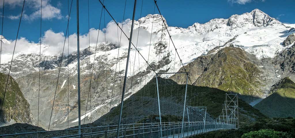
Near the start of the track, make sure you visit the Alpine Memorial, a sobering reminder of the many mountaineers who have perished in the park. Then climb to a viewing point of the magnificent Mueller Glacier and cross the first of three ‘swingy’ swing bridges over the Hooker River.
The track ambles up a wide valley with a profusion of wild flowers and along a boardwalk to protect the delicate eco-system. On a clear day, as you walk up the valley, the views of Aoraki-Mt Cook (3724m) and the glaciers and peaks of the Southern Alps - Ka Tiritiri o te Moana are absolutely jaw-dropping. The track ends at the Hooker Glacier Lake close to the foot of Aoraki-Mt Cook. The lake often has icebergs floating in it - once we spotted a ‘poodle-berg” - so it’s a chilly dip if you decide to take one.
There are few places in the world where you can stroll through such spectacular alpine terrain right to the foot of the country’s highest peak in an hour or so without guides, oxygen and a team of Sherpas or yaks. So take lunch with you and spend some time in the presence of Aoraki (the Cloud Piercer) as the mountain is known to local Maori.
Then retrace your footsteps and stay a night at White Horse Hill or Glentanner campgrounds, a lodge, or the famous Hermitage Hotel at Aoraki-Mt Cook village so you can watch the splendour of sunset and sunrise over ‘the Cloud Piercer’. Also visit the Sir Edmund Hillary Alpine Centre which showcases the Aoraki-Mount Cook region, its history, people and pioneer extraordinaire, Sir Ed himself.
There are dozens of spectacular walks and climbs to do in the park. Call at the DOC (Department of Conservation) office in Aoraki-Mt Cook village and talk to the highly- knowledgeable rangers there. They will suggest the best walk to suit your ability, time and hiking gear.
Getting there Start from White Horse Hill Campground and carpark at the end of Hooker Valley Road.

Omarama Clay Cliffs
Travelling along SH8 between the Lindis Pass and Omarama, you can see the bizarre moonscape of the Clay Cliffs in the distance. Often by-passed this is a remarkable natural phenomenon that many miss out on. So, don’t miss out. Take a detour up the 10km seriously-corrugated road, pay $5 per vehicle entry fee and take an hour or so to explore this place of astonishing beauty and wonder. Climb up narrow ravines amid towering cliffs and bizarre rock formations sculpted into organ pipes, pinnacles, spires and pillars by two million years of weathering.
Made up of layers of river gravel and lake silt formed by the flow of ancient glaciers, the resistant material remains while softer silt has eroded away to create this other-worldly landscape. It’s a miniature version of Cappadocia's landscape in Turkey and no less spectacular.
Explore More Trip Guides
- Trip Guide
Wellington's Best Walks
- 18 Places
- Trip Guide
West Coast Region Walks
- 10 Places
- Trip Guide
Otago's Amazing Day Walks
- 10 Places
- Trip Guide
Southland Region Walks
- 5 Places