


Bald Head Walk Trail
Experience bushwalkers need to check out this challenging 12.5 km return hike over the Flinders Peninsula in Torndirrup National Park, one of Australia’s most scenic coastal walks. You’ll have stunning views on either side of you, out to the Southern Ocean on one side and King George Sound on the other. Combine these stunning coastal scenes with the intoxicating smell of the peppermint trees lining the path and the sound of waves crashing against the granite cliffs, and you’ve got a sensory experience you won’t forget.
The trail starts about 100m to the left of the car park in Torndirrup National Park. Keep in mind the terrain is steep and difficult to pass in some sections so you need to be reasonably fit and have proper walking shoes. Oh, and remember your hat, water, sunblock and something warm to put on if the weather changes...

Ghost House Walk Trail, Yanchep National Park
Explore the remnants of an old abandoned homestead on Ghost House Walk Trail in Yanchep National Park. It may sound a little spooky but the ruins are well-lit and open and just one of the many points of interest along the 12.4km loop walk. You’ll also traverses wetlands, fields of wildflowers (in season) and a long stretch of Tuart forest. This is also one of the only spots in Western Australia where you can spot koalas in the wild!
The walk ends at Cabaret Cave where you can then walk back to Yanchep for a refreshing beer. You can also choose to take on another walk to go see the WWII bunkers, hire a boat to row over the lake or take a guided tour of the caves. End the day with a barbeque as the odd kangaroo hops past you in the park.

Wadjemup Bidi
Uncover the beauty and history of Rottnest Island by exploring one of the five sections of of the 45km Wadjemup Bidi. Walk the 9.4km track from Thomson Bay to Oliver HIll to explore the ruins of the Coastal Defence system set up during WWII or take on the 9.7km loop walk from Thomson Bay Settlement. You’ll feel like you’re walking on water as the trail leads you over the Lakes Boardwalk.
Historical relics from WWII can also be found on the 10km Salmon Bay track which crosses over the middle of the island. Other walks that make up the Wadjemup Bidi will take you past spectacular swimming lagoons, famous surf breaks and wildlife viewing points where you can spot dolphins, whales and New Zealand fur seals.

Yardie Creek Walk Trail
Cape Range National Park has no shortage of great day walks to choose from if you want to explore the beauty of Yardie Creek gorge by foot. The Yardie Creek Walk Trail is ideal if you’re looking for a gentle afternoon walk complete with stunning views of the gorge, Ningaloo Reef and beyond.
Follow the Yardie Nature Trail along the edge of Yardie Creek. At the end of the Nature Trail, the Yardie Gorge Trail begins. This section overlooks ancient Yardie Creek gorge and offers amazing views of limestone cliff faces, and the chance to catch a glimpse of wallabies, emus, kangaroos and an impressive array of birdlife.
Walking in Cape Range National Park is not recommended between December and March when temperatures in the park can exceed 40 degrees. Be careful of loose surfaces underfoot especially when walking on trails above the gorge. At any other time of year though please remember hat, sunblock, water and lunch and snacks, depending on which walk you choose to do.

Loop Walk, Kalbarri National Park
Take in the geological beauty of the Murchison River gorge in Kalbarri National Park on this challenging 8km loop walk. The walk offers great views of the winding gorge with its red and white layered cliff faces and expansive views out to the Indian Ocean. A highlight is Nature’s Window, a natural wind-eroded arch perfect to use as a frame for photos of the Murchison Valley.
The trail begins not far from the carpark at the top of the river gorge. It then winds down the banks of the Murchison River before climbing back to the top of the sandstone cliffs. Be prepared for challenging up-hill sections and scrambles over loose ground. And please remember to take water to drink along the trail, sunblock, a hat and something warm to wear in case the weather turns.

Meelup Reserve Trail
Pack your snorkel on this all day walk past some of the most stunning and secluded white-sand beaches in the Leeuwin-Naturaliste. There’s a vast array of sea life to observe, including seals and dolphins, as well as wildlife such as kangaroos, snakes and a plethora of bird life - honey eaters and cormmorants to name a couple. For the botanists out there you’ll also pass through beautiful flora - like the peppermint forest. Another geographical highlight of this 7.4km walk is the popular swimming and picnicking spot of Meelup Beach. With it’s extremely calm and crystal-clear water, it’s the perfect spot to snorkel or try Castle Rock or Eagle Bay, a little further up the coast. There are great barbeque facilities and picnic tables on the grassy verge by the beach, so do remember to pack lunch.
The trail starts in Old Dunsborough where the Meelup Nature Reserve begins. You’ll head past Curtis Bay, Point Picquet before finishing at Eagle Bay. If you have the energy, walk back the way you came or catch a taxi at Eagle Bay.

Summit Trail, Mount Augustus
If you’ve conquered Uluru (Ayers Rock) and are ready for a mightier challenge, then the summit trail up Mt Augustus is for you. You can find what has been described as the biggest rock in a remote part of the Outback, 320km east from the nearest town of Carnarvon.
There are two tracks available which both lead to the summit. They’re both 12km long but expect the more challenging Gully Trail track to take 7 hours while the summit track can be completed in 6. Take your time to check out some of the ancient Aboriginal rock art and the extensive wildlife on the way to the summit. At the top, you’ll be able to see right across the surrounding plain to the distant ranges as the views are spectacular.
Be sure to leave early to avoid the heat of the day. It’s also highly recommended that you advise Mount Augustus Tourist Park (or the national park volunteers) that you are going on the summit trail. And as always, please pack lots of water, sunblock, a hat, some lunch and something warm to wear in case the weather changes.

Numbat Trail
Spot echidnas, kangaroos, emus and more on the 12km Numbat Trail though the Paruna Wildlife Reserve. The reserve was created by the Australian Wildlife Conservancy to protect threatened species of native plants and animals. To help protect the environment and its inhabitants, there are only a limited number of visitors allowed per day. Make sure you make a booking, either by emailing visitparuna@australianwildlife.org, and pay the $5 fee before you visit the park.
Because of the need to book in advance, you’re likely to not see many other people on the track. As well as the abundant wildlife, keep an eye out for the vibrant orange bark on the Wandoo and Powderbark forest. The forest then makes way for dense scrubland before reaching a ridgeline where you’ll be able to admire the green views of the Avon River below.

Greenbushes Loop
Visit several historic town sites and take in beautiful views of the Blackwood farming valley on the Greenbushes Loop track. This 16km walk begins at the Greenbushes Discovery Centre in the centre of town. Along the way you’ll visit the historic relic of Schwenke’s Dam, remnant of the old Vultan Tin Mine and Mt Jobes Dam. The loop also takes in a section of the Bibbulmun Track before leading back to Greenbushes where you can treat yourself to an ice cream or refreshing ale at one of the two pubs in town.

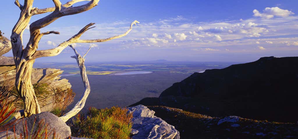
Bluff Knoll, Stirling Range National Park
Take on the third highest peak in Western Australia in Stirling Range National Park. Due to its height at 1095km and proximity to the coast, Bluff Knoll has a unique climate perfect for more than 1,000 species of wildflowers and flowering plants to flourish including bright Mountain Bells and the Queen of Sheba Orchid. The information shelters along the path will provide you with information on the unique flora and fauna around you.
As you walk up to the summit, take a moment to look around you at the interesting shapes and patterns in the rocks of the mountain. Bluff Knoll was called Pualaar Miial, meaning great, many-faced hill, by the local Aboriginal people due to the human face-shaped rocks on the mountain. The 6km Bluff Knoll walk starts at a large trailhead interpretive shelter at the carpark. Be sure to pack some water and lunch as well as layers and a raincoat as mountain mists, wind chill, snow and rain is common up high even during warm weather.
Explore More Trip Guides
- Trip Guide
Tasmania's Top Walks
- 12 Places
- Trip Guide
New South Wales Best Day Walks
- 10 Places
- Trip Guide
Victoria's Incredible Short Walks
- 10 Places
- Trip Guide
Queensland's Most Beautiful Walks
- 10 Places