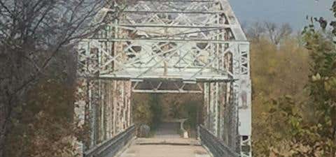

Illinois’ Centennial Trail runs through parts of three suburban counties from Willow Springs Road to Romeo Road/135th Street southwest of Chicago. The trail occupies a thin strip of land between the Des Plaines River and the Chicago Sanitary and Ship Canal, and features a historic swing bridge. Coursing primarily through forest, the trail is ideal for bird and wildlife watching.
The site of the trail is part of the Illinois & Michigan Canal National Heritage Corridor, and the trail connects directly at its southern end with the northern portion of the nearly 70-mile Illinois & Michigan Canal State Trail. Between Kingery Highway S./State Route 83 and Willow Springs Road, the Centennial Trail also parallels the John Husar I&M Canal Trail, which follows the southern bank of the Chicago Sanitary and Ship Canal.
Length: 13 miles
Trail end points: Willow Springs Rd. (Willow Springs) to E. Romeo Rd. at Isle a la Cache Forest Preserve (Romeoville)
Trail surfaces: Asphalt
Info: http://www.traillink.com/trail/centennial-trail-(il).aspx
Be the first to add a review to the Centennial Bike Trail.
/-87.8885898855746,41.7991179747714,14/300x172@2x?access_token=pk.eyJ1Ijoicm9hZHRyaXBwZXJzIiwiYSI6ImNsczF1Y3RwcTA0ZmgycHAwbngweHlmbDAifQ.G6RP_RvWmMx8yNQSHb3PGQ)
Centennial Bike Trail
Hours
Problem with this listing? Let us know.
Has RV parking changed? Let us know.
-
Parking
-
Pets Allowed
-
Restrooms
-
Wifi
-
Wheelchair Accessible
-
Credit Cards Accepted
Nearby Hotels
Related Trip Guides
- Trip Guide
Pay Tribute and Reflect at These US Monuments and Memorials
- 14 Places
- Trip Guide
The top things to do on an I-40 road trip
- 35 Places
- 49:44
- 2,851 mi
- Trip Guide
Ultimate Offbeat Guide to Chicago, Illinois
- 15 Places
- Trip Guide
- 1 Week
A road trip along the Great River Road
- 35 Places
- 37:29
- 1,907 mi