“The largest Glaciers in Yosemite”
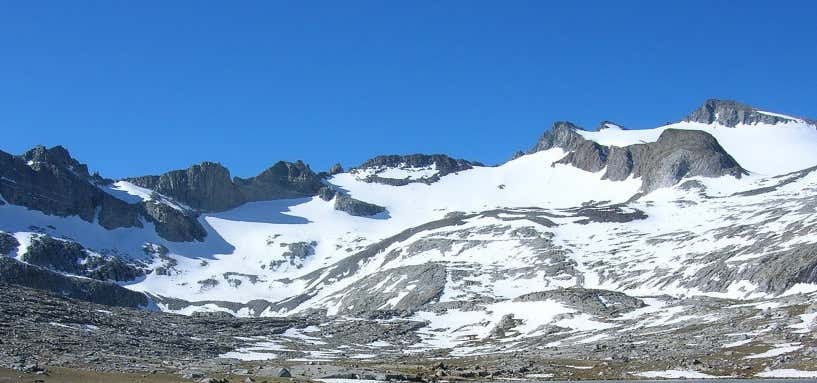
Mount Lyell is the highest point in Yosemite National Park, at 13,120 feet (4,000 m). It is located at the southeast end of the Cathedral Range, 1.2 miles (1.9 km) northwest of Rodgers Peak. It is named after Charles Lyell, a well-known 19th century geologist. The peak also has the largest glaciers in Yosemite, Lyell Glacier. Mount Lyell divides the Tuolumne River watershed to the north, the Merced to the west, and the Rush Creek drainage in the Mono Lake Basin to the southeast. The most common approach to Mount Lyell is from Tuolumne Meadows on a highly traveled section of the John Muir Trail. The round trip is approximately 25 miles (40 km) and involves 4,500 feet (1,400 m) of elevation gain when starting from the Tuolumne Wilderness Office. The hike is easy from Tuolumne Meadows, following the Tuolumne River to the head of the Lyell Canyon, and becomes moderate as it approaches Donahue Pass . Before reaching Donahue Pass, the route leaves the trail and heads south towards Mount Lyell.
Be the first to add a review to the Mount Lyell.
/-119.271569,37.739424,14/300x172@2x?access_token=pk.eyJ1Ijoicm9hZHRyaXBwZXJzIiwiYSI6ImNsczF1Y3RwcTA0ZmgycHAwbngweHlmbDAifQ.G6RP_RvWmMx8yNQSHb3PGQ)
Mount Lyell
Hours
Problem with this listing? Let us know.
Has RV parking changed? Let us know.
-
Parking
-
Pets Allowed
-
Restrooms
-
Wifi
-
Wheelchair Accessible
-
Credit Cards Accepted
Nearby Hotels
Related Trip Guides
- Trip Guide
Pay Tribute and Reflect at These US Monuments and Memorials
- 14 Places
- Trip Guide
The Ultimate Guide To Joshua Tree National Park
- 53 Places
- 11:44
- 408 mi
- Trip Guide
The top things to do on an I-40 road trip
- 35 Places
- 49:44
- 2,851 mi
- Trip Guide
The top things to do on an I-10 road trip
- 55 Places
- 56:13
- 3,026 mi