“awesome cascades hidden away”
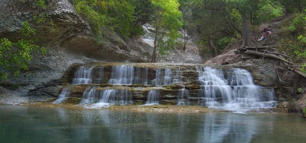
Exit from I-35 and head west on FM 2484 for about one mile. Turn right onto FM 1670 and head north for 3.5 miles. Look for the park entrance on the right. Proceed down the winding driveway to the parking area near the trail head. Just over a small ridge lies the crown jewel of the park, the falls from which the park derives its name. The trails at Chalk Ridge present something of a mystery. At the trailhead, marked on the map by a waypoint of the same name, one finds an interpretive sign pointing out some of the animals one might find on the hike, but no trail map. So I set about mapping as much of the trail as I could in the time I had. Little did I realize that I would map a bit more than planned. A winding boardwalk conveys the trail across a wide creek bed near the start of the hike. The trail starts off along a straight berm overlooking the Lampasas River to the left. The gravel surface here through the falls provides a very easy hike for those who are looking for a simple stroll. At perhaps a quarter mile into the hike a large wooden bridge provides a passage over a stream bed that empties into the river. Just over a small ridge lies the crown jewel of the park, the falls from which the park derives its name.

A pleasant landscape, including the falls, which are not as large as the pictures seem to show. After a stroll down a wide dirt path to a bridge, you can cross over and find yourself in a maze of unmarked paths leading in every direction; or you can descend to the creek bank, turn right, and make your way straight to the falls. The place is popular with locals, and there's only room for maybe one or two groups of people at the site. Small kids will love it, though.

Chalk Ridge Falls is closed for a few months due to construction by the Army Corps of Engineers. Sad day, we couldn't see the falls.
If you are traveling from I-35 you will turn in right before the dam!
This was a great stop on our trip from San Antonio back to Dallas, natural waters to dip in, our daughter loved it! It's a free way to explore a small natural splendor! Not a bad hike at all, more like a trail walk to enjoy. Suggest bringing shoes and a swimsuit, it's muddy on the edges and rocky in the water.
Directions say park on the right. You have to go over the dam and it is on the left with a sign by the road kids loved it!!! Will be back with swim suits.

The marker on the map marks the wrong location. You can obtain a map of the main trails from the lake office which is actually where the marker on this map is.
I live on the other side of the lake, so I come here often. There are actually several falls within the park with about 5 miles of trails. There are two main trails that begin from the parking lot; one along each side of the river.
If you hike far enough, you will actually end up in a boy scouts campground as there are no boundary lines.
More pictures and info for anyone interested: http://nuttyhiker.com/chalk-ridge-falls-texas/
Be the first to add a review to the Chalk Ridge Falls.
/-97.5287525,31.0202,14/300x172@2x?access_token=pk.eyJ1Ijoicm9hZHRyaXBwZXJzIiwiYSI6ImNsdjQ5N2VtZDA2bW8ycW13ZHAxeGhjbjkifQ.UIccpoAxc7g3BAuK4s9vjg)
Chalk Ridge Falls
Hours
Problem with this listing? Let us know.
Has RV parking changed? Let us know.
-
Parking
-
Pets Allowed
-
Restrooms
-
Wifi
-
Wheelchair Accessible
-
Credit Cards Accepted
Nearby Hotels
Related Trip Guides
- Trip Guide
Pay Tribute and Reflect at These US Monuments and Memorials
- 14 Places
- Trip Guide
The ultimate guide to Big Bend National Park
- 13 Places
- Trip Guide
The top things to do on an I-40 road trip
- 35 Places
- 49:44
- 2,851 mi
- Trip Guide
The top things to do on an I-10 road trip
- 55 Places
- 56:13
- 3,026 mi