“A 5.5 mile round trip”
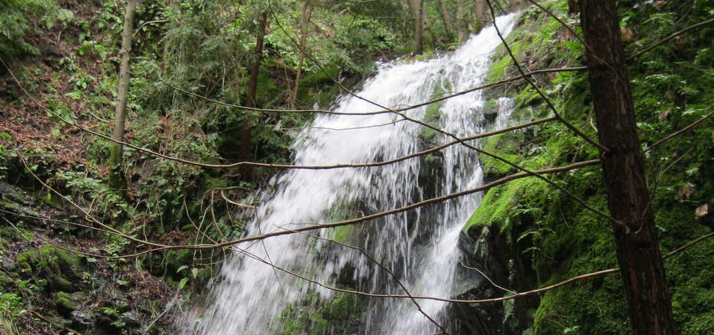
Perched high on the western slope of the Santa Cruz Mountains, among frequent fogs (and just above occasional smogs) Castle Rock State Park offers dramatic rock formations and quiet forest paths. Castle Rock, the park’s 3,214-foot high point, is a sandstone formation that appeals to rock climbers, geologists and photographers. A thick evergreen forest obstructs the view from Castle Rock. Much better panoramas are to be had atop Goat Rock, a sandstone outcropping that offers hikers clear-day views of the San Lorenzo Valley and Pacific Ocean. By the early 1900s, Castle Rock was already a tourist attraction. Inter-Urban streetcars carried visitors from the Santa Clara Valley up to Congress Springs (just above the present-day town of Saratoga). Intrepid travelers then hiked (or hired a horse and buggy to carry them) to Castle Rock. For a pleasant loop through the park, join Saratoga Gap Trail, which visits Castle Rock Falls and leads to Castle Rock Trail Camp. Your return is via Ridge Trail, which parallels Saratoga Gap Trail at higher elevation and offers grand clear-day views. Directions to trailhead: From Highway 17 just north of Los Gatos, exit on Highway 9, winding through the town of Saratoga and ascending the Santa Cruz Mountains to meet Highway 35. From the junction of Highway 9 and Highway 35 (Skyline Blvd.) drive south on 35 for 2.5 miles to the signed state park lot on the right. The signed trail begins at the west end of the lot. The hike: Begin descending on Saratoga Gap Trail under the shade of oaks and ferns, soon passing the side trail leading to Castle Rock. The main path follows a creek and crosses on a footbridge. You’ll pass a signed trail (your return route) leading to Goat Rock, and continue to Castle Rock Falls, 0.75 mile from the trailhead. Judging by the substantial looking observation platform, you might expect a more overwhelming spectacle than the hundred-foot Kings Creek cascade known as Castle Rock Falls. Ah, but never mind the falls located just up-canyon, take a look down-canyon to the San Lorenzo River watershed and the wide blue Pacific; this view may have been the main reason for the erection of an observation platform. The path ascends wooded hillsides and, 0.5 mile beyond the waterfall, leaves behind the trees and climbs into the chaparral. From this elfin forest, hikers get clear-day views of Monterey Bay. The trail alternates between brushy hillsides and madrone- and oak-filled canyons on the slope of Varian Peak, named for physicist-conservationist Russell Varian, who was instrumental in the creation of the state park. Russell Point Overlook offers a good view, but a nicer rest/lunch stop is 0.25 mile farther at Castle Rock Trail Camp. The camp, located in a knob-cone pine forest, has water and picnic tables. From the camp, you’ll retrace your steps as far as the junction with Ridge Trail, which you’ll join on an ascent of oak- madrone-, and boulder-dotted slopes. This path leads a mile to another observation point and to a terrific interpretive center, a collection of outdoor exhibits that really show the lay of the land. (The geography lesson is particularly valuable when fog blankets the Santa Cruz Mountains, as if often does.) On the final segment of this day hike, you’ll loop past Goat Rock, a favorite of local climbers, then descend to rejoin Saratoga Gap Trail. Turn left and return to the trailhead.
Be the first to add a review to the Castle Rock Falls.
/-122.0955722,37.2306325,14/300x172@2x?access_token=pk.eyJ1Ijoicm9hZHRyaXBwZXJzIiwiYSI6ImNsdjQ5N2VtZDA2bW8ycW13ZHAxeGhjbjkifQ.UIccpoAxc7g3BAuK4s9vjg)
Castle Rock Falls
Hours
Problem with this listing? Let us know.
Has RV parking changed? Let us know.
-
Parking
-
Pets Allowed
-
Restrooms
-
Wifi
-
Wheelchair Accessible
-
Credit Cards Accepted
Nearby Hotels
Related Trip Guides
- Trip Guide
Pay Tribute and Reflect at These US Monuments and Memorials
- 14 Places
- Trip Guide
The Ultimate Guide To Joshua Tree National Park
- 53 Places
- 11:44
- 408 mi
- Trip Guide
The top things to do on an I-40 road trip
- 35 Places
- 49:44
- 2,851 mi
- Trip Guide
The top things to do on an I-10 road trip
- 55 Places
- 56:13
- 3,026 mi