

Everything's spectacular in Tasmania and we found it hard to pick the top ten walks but we did. From ancient rocks on Maria Island from the Triassic Period to one of the ten beaches in the world, there's a good variety here with equally spectacular names: Devils Kitchen, Sphinx Rock, Walls of Jerusalem, Wineglass Bay and Narcissus Hut!


"Maria Island, Tasmania"

Organ Pipes Loop Walk
Mt Wellington is Hobart’s outdoor playground popular with bushwalkers and rock climbers looking to explore its unique geological formations and appreciate expansive views of the city. One of the park’s most famed attractions, the fluted column rock formations known as the Organ Pipes, can be reached by a 4-hour loop walk.
You’ll need to be prepared for some moderate climbing to reach the Organ Pipes. Once you’re there, you can walk beneath these mighty structures while rock climbers dangle precariously above you. On the way up, you’ll see historic huts and the aptly named Sphinx Rock and Crocodile Rock.
After reaching the Organ Pipes, climb further to the summit of Mt Wellington to soak in the glorious views of Hobart and the Derwent River.

Devils Kitchen to Waterfall Bay
Some of the steepest sea cliffs in Australia can be found along this stretch of coast in Tasman Peninsula National Park. This exhilarating 3 hour walk will have you walking along these wild clifftops before leading you to the Peninsula’s star attraction, Waterfall Bay. From Waterfall Bay you’ll be able to look out onto a waterfall, which, after rain, plummets straight into the ocean.
Another highlight is the view down to the rough and wild sea crashing into the cave under the rock formation known as Paterson's Arch. If you have time and energy to spare when you’re done with the cave, climb to the top of Clemes Peak or the higher Tatnells Hill.
After you’ve finished walking for the day, take a tour of the famous Port Arthur Historic Site, Australia's most well-preserved convict settlement.

Fossil Cliffs Walk
Head out to Maria Island for a weekend to discover its geological wonders and convict history. The 4.5km Fossil Cliffs Walk in the Maria Island National Park will first take you past historic site of Convict Barn, a building erected as a store for agricultural produce. Make sure you take your time to wander around this open-air museum, complete with abandoned farming equipment. You’ll then weave your way through an historic cemetery before reaching Fossil Bay. Explore the lower rock shelf to see a variety of 300 million year old fossils including sea fans, coral, scallop shells and sea lilies.

Painted Cliffs Walk
The Painted Cliffs walk is no less impressive. Make sure to set off around low tide to allow easy access into the rock platform adjacent to the Painted Cliffs. Here you’ll find exposed rock formations stained in the most beautiful patterns by iron oxides. The iron oxides probably occurred millions of years ago, during the Jurassic Period, as water gently percolated down through the already formed sandstone. Sea spray hitting the rocks inside the cave has also dried, forming crystals of salt which add to this natural wonder. On the way back, stop off at Oast House. Built during the second convict period in around 1844, this building housed hop kilns which were used during the drying of hops from nearby fields. The building was then later used for crushing grapes and as an abattoir.

Mount Amos Walking Track
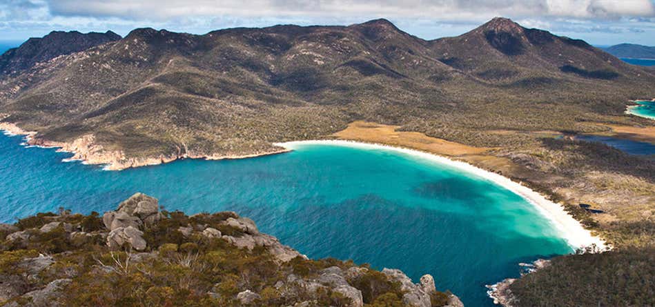
Infinitely less visited, but infinitely more spectacular, than Tasmania's famed Wineglass Bay Lookout is the summit of Mt Amos, immediately above the lookout. While the lookout platform offers a glance at the perfect curve of the state's most famous beach, the mountain above provides a mesmerising perspective far beyond the stripe of sand.
Begin on the trail to the lookout, but after just a few metres take the signposted track to the left. This stays on flat ground for a while, cutting along the base of Mt Amos, but don't be fooled - it's about to get very steep. When it does turn up onto the mountain, it does so with intention - you'll scale granite slabs that require the use of hands as much as feet. These get slippery and dangerous if it's wet, so assess the weather forecast carefully before you set out. Pause often and turn around to take in the view back over Coles Bay, often filled with boats and kayaks.
The steep ascent only flattens as you come onto the summit, which is a jumble of giant boulders. Wineglass Bay is a swoosh of white sand 450 metres below you, with Mt Graham and Freycinet rising behind it. Far in the distance you can even see Maria Island. Descend the way you came up - and take it very easy as steep up is tricky back..

Wineglass Bay Lookout to Wineglass Bay
Touted as one of the top 10 beaches in the world, Wineglass Bay in Freycinet National Park is a stunning crescent-shaped Bay framed by giant granite peaks. This 3 hour return will provide you with the best views of the bay from the vantage points of Mt Amos and Mt Mayson.
The track begins with a short, fairly steep climb to the saddle between the two mountains. It then leads to a lookout, where you’ll be able to see spectacular views of Wineglass Bay. You’ll then have a choice of heading back to the carpark or, if you want to double the length of the walk, climb down to the beach.

Walls of Jerusalem National Park
Go on an adventure to carve out your own walking trail in the remote Jerusalem National Park. With no roads in or out, you’ll have to walk into the park before you can even begin exploring the park’s diverse landscape including towering mountain peaks, glassy lakes and fields of wildflowers and alpine vegetation.
You can camp in the park but be prepared take everything in and out with you as there are no visitor facilities (and you want to be sure you have minimal impact during your stay here.)
Hiking in Walls of Jerusalem National Park should only be attempted by experienced bushwalkers who also have strong navigation and first-aid skills. The weather in the park can also change drastically and quickly so you’ll need to pack appropriately.

Narcissus Hut to Cynthia Bay walk
If you’re looking for a full day walk, head to Cynthia Bay where you can jump on a ferry to Narcissus Hut. From there, it’s a 15 km walk back to your starting point along the last section of the famous Overland Track.
The track from Narcissus Hut juts out in a southwest direction across grass-plains where you’ll be able to take in stunning views of the mountains. The track then winds through forest and the edge of Lake St Clair.
Stop for lunch at the small beach near Echo Point Hut before continuing on through vegetation. You’ll have plenty of opportunities to take detours back to the lake’s edge on the walk back. There’s also a high chance of spotting wallabies and wombats and even a platypus.

Ida Bay to Southport Lagoon
Hike along early 1990s railway tracks and explore rugged South Tasmania coastline on this 20km return hike from Ida Bay to Southport Lagoon. The walk begins at the Ida Bay Railway station at Lune River where you’ll follow the railway line to Elliot Beach. Once at Elliott Beach, there’s a day use shelter and jetty to set out a picnic before heading off on more rugged walking tracks. Traverse heathland and a few gentle inclines before continuing downhill through open bushland to Southport Lagoon. Just before you reach the lagoon, there’s a chance to take in vast views of the lagoon and the Southern Ranges beyond.
You can shorten this hike by 6km if you take the Ida Bay Train to Elliot Beach and begin the walk from there.

Cape Raoul
Emerge from lush bushland to take in expansive views of 200-metre tall cliffs and deep blue ocean stretching as far as the eye can see on the Cape Raoul trail. The path starts off in bushland and wild vegetation in Tasman National Park before narrowing as you walk right on the edge of the cliff. The hiking can be challenging along the cliff face but you’ll have stunning views of the cliffs at Cape Raoul, Cape Pillar and Bruny Island to keep you inspired.
The hike to Cape Raoul is 12 km round trip if you turn around at the viewpoint by the depression at the top of the cape or it’s a 14 km round trip if you carry on to the very end of Cape Raoul.
You need to purchase a pass before visiting Tasman National Park. This can be accessed at http://www.parks.tas.gov.au/?base=914.

Crescent Beach Track
Welcome to sand dune paradise on this walk to the aptly named Crescent Beach on Tasmania's Tasman Peninsula, where it's almost compulsory to slide down the dunes on your bum or board.
The walk begins at the car park beside Remarkable Cave (it's worth the few minutes to walk down to the cave entrance to watch the Southern Ocean surge through the hole in the cliffs). You then head off in the opposite direction, walking through coastal scrub and sandy ground to a fissure in the cliffs known as Maingon Blowhole. It's worth peeping over the edge to get a sense of the depth of the blowhole. But don't get too close.
As you near Crescent Beach, around four kilometres from the car park, look for the turning to the right to take a short detour onto low Mt Brown, with its open summit providing an aerial perspective on the beach ahead. Back at the junction, descend to the long beach, from where there are gorgeous views across to Tasman Island and Cape Pillar, the star feature of one of Tasmania's other great bushwalks - the multi-day Three Capes Track.
Head to the far end of the beach to find the highest of the dunes, and don't be surprised if you find kids and other hikers sliding down them on boogie boards or toboggans. It's a Tasmanian ritual.
Return to the car park along the same route.
Explore More Trip Guides
- Trip Guide
New South Wales Best Day Walks
- 10 Places
- Trip Guide
Victoria's Incredible Short Walks
- 10 Places
- Trip Guide
Queensland's Most Beautiful Walks
- 10 Places
- Trip Guide
Western Australia's Best Walks
- 10 Places