Beartooth Highway Road Trip Guide: Scenic Drive From Red Lodge to Yellowstone
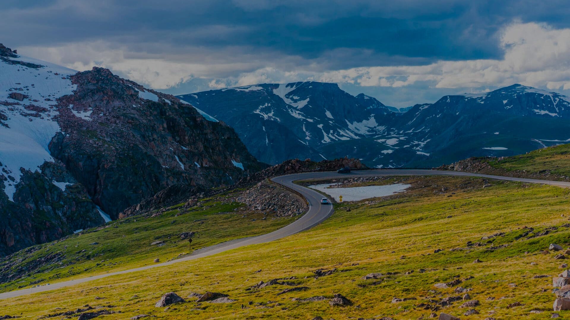
Nicknamed the “Highway to the Sky,” the 69-mile Beartooth Highway connects Yellowstone National Park and Red Lodge, Montana.
Beartooth Highway Road Trip Overview: Distance, Elevation, and Route
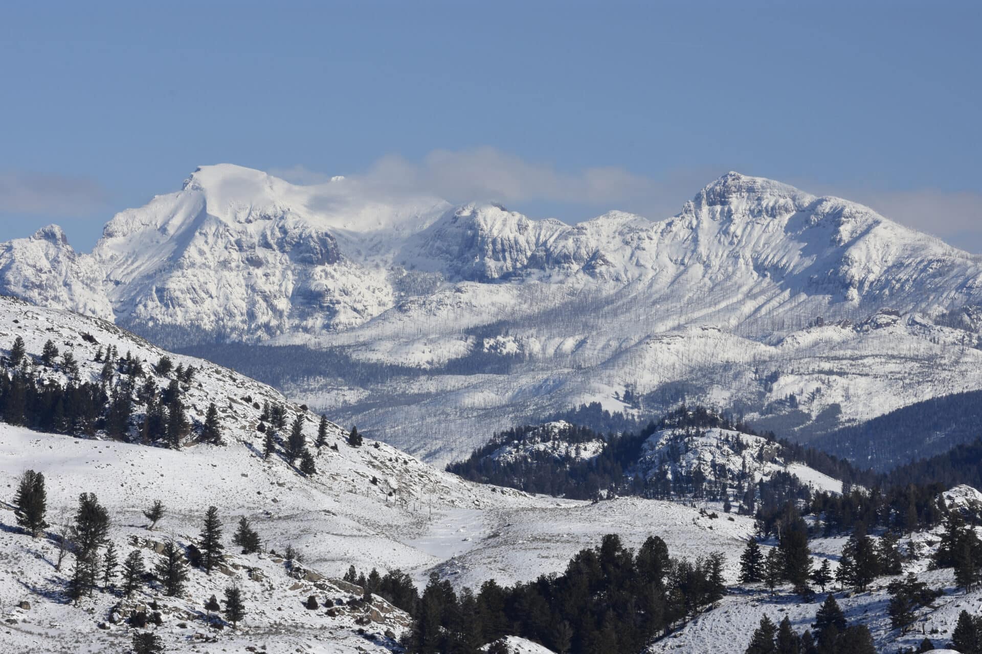
The Beartooth Highway, nicknamed the “Highway to the Sky” and named an All-American Highway, is a segment of U.S. Route 212 that connects Yellowstone National Park to Red Lodge, Montana. The 69-mile highway winds and climbs to more than 10,000 feet above sea level to reach Beartooth Pass. The road passes through alpine forest and arctic tundra, is full of sheer drop-offs, and delivers constant views of lakes and 12,000-foot peaks. The descent carries the highway into the state of Wyoming before returning to Montana to reach Cooke City and the northeast entrance of Yellowstone.
Key Takeaways
Everything you need to know about a Beartooth Highway road trip
Download the mobile app to plan on the go.

Share and plan trips with friends while discovering millions of places along your route.
Get the AppBeartooth Highway Opening Dates, Closures, and Driving Conditions
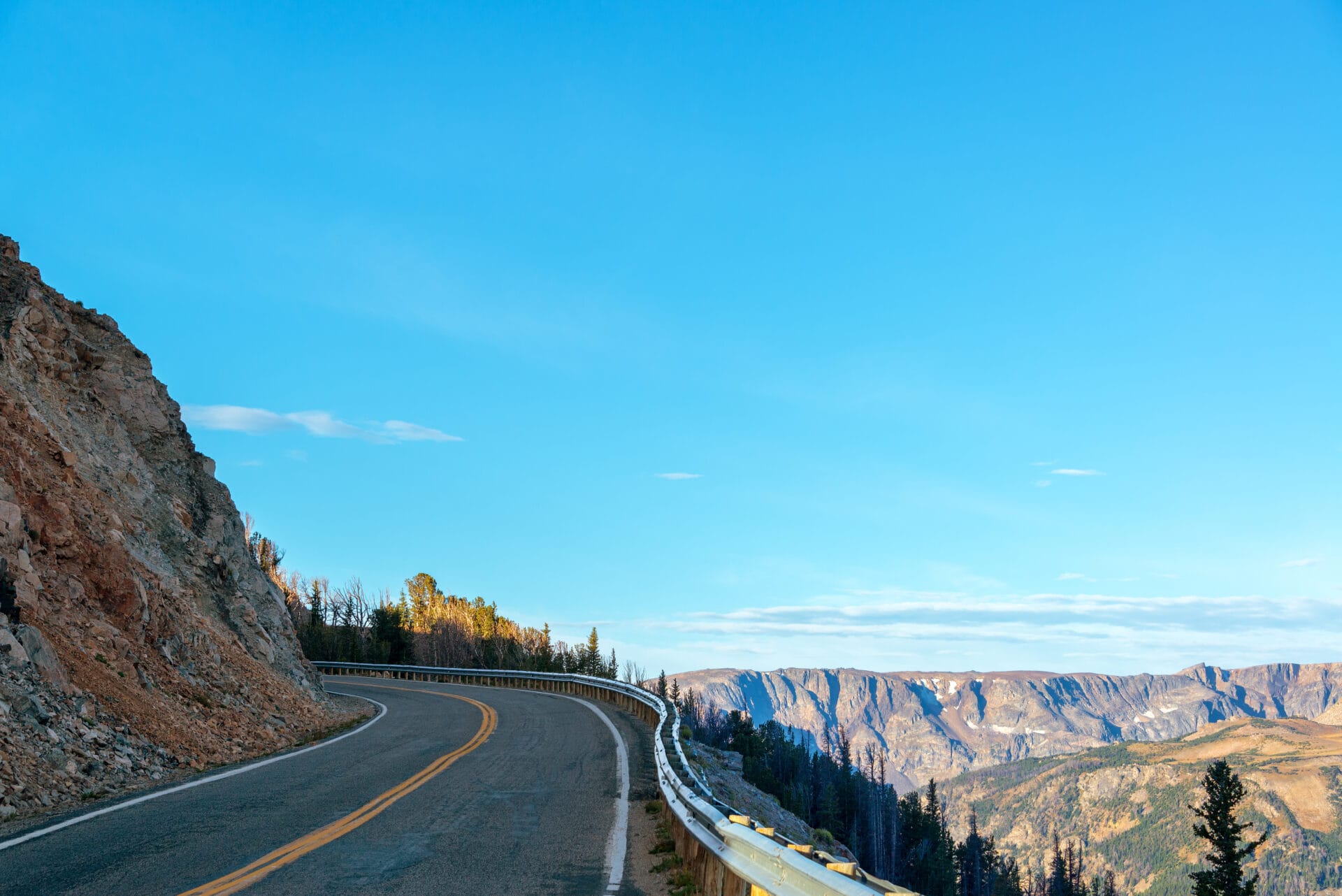
What the Beartooth Highway lacks in length, it more than makes up for in dramatic scenery. It’s also not a drive to take lightly. An undivided two-lane road that lacks formal pullouts in some segments, and closes to traffic in the winter, the highway has a reputation as a dangerous drive.
Muddled jurisdiction over the road, and its passage through some of the most rugged country in the U.S., makes maintenance an ongoing challenge, and the climb of more than 5,000 vertical feet to the Beartooth Pass is fraught with switchbacks and sheer drop-offs. Drivers, especially those behind the wheel of an RV, are advised to check their brakes, keep their eyes sharp, and proceed with caution on a road that includes high-speed stretches, plodding ascents, and dramatic downhill sections.
That said, hundreds of thousands of people take this spectacular drive each year, generally between mid-May and mid-October. The road is typically closed the rest of the year due to snow in the high mountain pass, which can see snowfall even in mid-summer.
The highway was originally built to provide access from Red Lodge to the northeast gate of Yellowstone National Park, so many roadtrippers incorporate the Beartooth drive into a park visit.
Best Stops on Beartooth Highway: Overlooks, Hikes, and Campgrounds
Rock Creek Vista
Rock Creek Vista: If you’re only going to make one stop at a scenic overlook on the Beartooth Highway, make it Rock Creek Vista. From 9,190 feet above sea level, you’ll enjoy views of the Rock Creek Valley and the Hellroaring Plateau from an observation platform, complete with interpretive plaques to help explain what you’re seeing. Plus, this pullout has the nicest public restrooms on the Beartooth Highway.
Beartooth Basin Summer Ski Area
Beartooth Basin Summer Ski Area: Novelty alone would tempt skiers and snowboarders to get in some summer runs at Beartooth Basin, which opens after the Beartooth Highway gates go up in May and runs its lifts until the sun finally melts the snow, usually around early July. Sometimes described as a backcountry ski area with lift service, Beartooth is known for challenging terrain: Some slopes have a pitch of 50 degrees.
Top of the World Resort
Top of the World Resort: This small general store near the top of Beartooth Pass is a popular stopover as it’s the only place to get gas or pick up camping supplies for dozens of miles in either direction. Step into the rustic log cabin, which dates to the 1930s, and spend some time browsing the fishing gear, stuffed animals, and souvenirs.
Clay Butte Lookout
Clay Butte Lookout: The views of Shoshone National Forest from this former fire lookout are reason enough to take the short detour off Beartooth Highway, but there’s also plenty of history. Built in 1942 by the Civilian Conservation Corps, the restored lookout building is listed on the National Register of Historic Places, and exhibits explain how a network of staffed lookouts like this once served as the front line against forest fires.
Crazy Creek Falls
Crazy Creek Falls: The height of this waterfall won’t blow you away, but the power of spring runoff water surging 30 feet wide down a long slope of granite is more than impressive—and even a little scary. Loud up close, the falls make for some lovely white noise if you’re spending the night at the nearby Crazy Creek Campground.
Beartooth Highway history
From Tribal Routes to Yellowstone Access (Crow Territory; 1871 Army Crossing)
Native Americans long used the Beartooth Pass to cross the Beartooth Mountains, as did the U.S. Army when returning from an inspection of the new Yellowstone National Park in 1871.
Building the Road: 1931-1936 Construction Timeline
Construction on the road began in 1931, with different teams of workers tackling the ascent to the Beartooth Pass from Red Lodge and the challenging switchback section of the road on the western side of the pass.
It wasn’t until 1936, however, that a road was completed through the pass, largely fueled by a desire by residents of Red Lodge, Montana, to position the town as a gateway to Yellowstone, and support the local mining industry.
Who Maintains the Beartooth Highway Today? (Funding Gaps, Split Jurisdiction)
Financing issues caused problems that persist to this day. Funding for the highway came under a federal law that restricted national park approach roads to a maximum of 60 miles; because the Beartooth Highway stretched to more than 68 miles, the road came under multiple jurisdictions, including the federal government and the U.S. Forest Service.
The federal law did not provide a maintenance budget for the highway, sparking a debate between the federal government and the states of Montana and Wyoming about who was responsible for maintaining the road. This led to an unusual situation where the Montana Department of Transportation maintains the segment of highway from Red Lodge to the Montana/Wyoming border, while the National Park Service maintains the rest—a rare example of the agency having jurisdiction of a road that sits entirely outside of park borders.
A Beartooth Highway road trip by segments
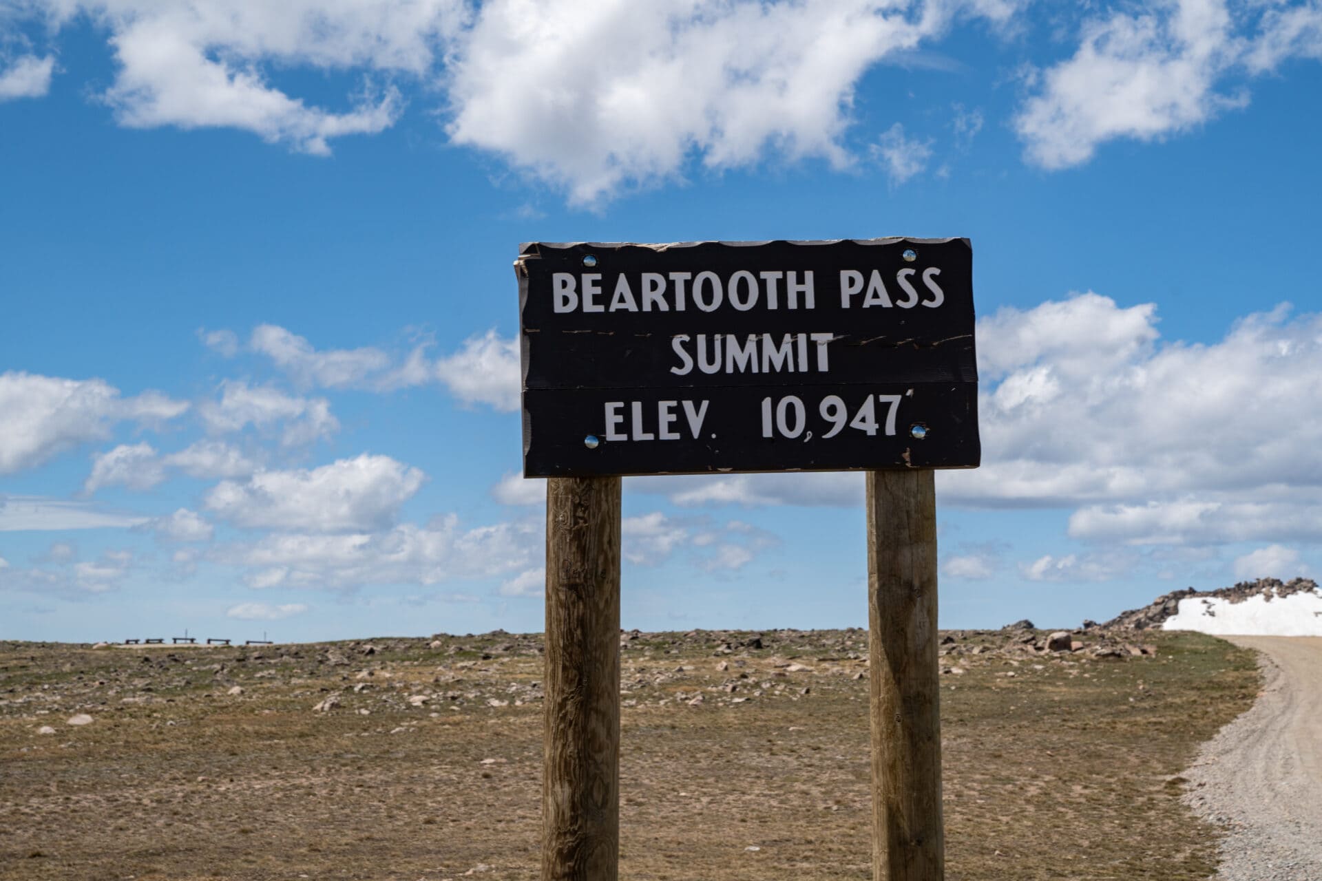
The Beartooth Highway can be divided into two distinct segments—west and east of the Beartooth Pass. From the canyon floor in Red Lodge, Montana, it’s about a 25-mile drive to the top of the 10,947-foot pass through the Absaroka-Beartooth mountains. The road then descends via switchbacks and over rolling hills into Wyoming, crossing flatter terrain before approaching Cooke City and the gate for Yellowstone National Park.
Route Guide: Red Lodge to Beartooth Pass
This compact Montana mountain town benefits fully from its position as a gateway to both the Beartooth Highway and Yellowstone National Park. Once part of the territory of the Crow tribe, and later a coal-mining boom town, Red Lodge today boasts a historic district lined with 19th and early 20th century public and commercial buildings, a museum, wildlife sanctuary, golf course, small airport, and rodeo grounds. The circa 1893 Pollard Hotel sits at the center of town, and other lodging options include independent small hotels and inns, bed-and-breakfasts, and a Quality Inn. Restaurants include steakhouses and saloons but also taco joints and upscale dining at the Pollard Hotel and Prerogative Kitchen.
Along with the chambers of commerce in Red Lodge and Cooke City, the ranger station is your best source of up-to-date information about driving the Beartooth Highway, including details on road closures and recreation in the Beartooth and Pryor Mountain Ranges. The U.S. Forest Service’s Beartooth Ranger Station is located at 6811 U.S. Route 212 in Red Lodge and is open Monday through Friday from 8 a.m. to 4:30 p.m.
Take West Fork Road to Ski Run Road to visit this alpine ski area outside of Red Lodge. With its summit on 9,416-foot Grizzly Peak, Red Lodge Mountain offers skiing and snowboarding on 70 ski runs serviced by six lifts, across 1,635 acres of terrain. It’s generally open late November to mid-April for skiing, and in summer for golf.
Perry’s RV Park and Campground
Open May to October, this private campground has 44 RV and 15 tent sites with utility hookups, plus seven cabins and showers for guest use. Fishing is available in nearby Rock Creek.
One of the few hotels on the Beartooth Highway, Rock Creek Resort has 87 guest rooms, apartments, town homes, and a cabin. Guest amenities include an indoor pool and a restaurant overlooking Rock Creek.
Located in the Custer Gallatin National Forest 7 miles south of Red Lodge, the Sheridan Campground has nine campsites, picnic tables, campfire rings, and vault toilets. Smaller sites may be unsuitable for RVs and trailers. Open from May through September.
Seven single-family campsites are located near Rock Creek and include picnic tables, fire rings, drinking water, and vault toilets. Open from May through September.
The trailhead for the Bear Track Trail is 8.4 miles west of the Beartooth Ranger Station, directly on Beartooth Highway. The 12.5-mile trail climbs from Rock Creek Canyon to Silver Run Plateau, connecting to the Silver Run Plateau Trail at 5 miles and the Timberline Trail at its terminus. All three trails lie within the Custer Gallatin National Forest.
At 9.1 miles from the Beartooth Ranger Station you’ll find the trailhead for the Lake Fork Trail, a popular 9.5-mile hike from Lake Fork Road (Forest Road 2346) to Sundance Pass that passes Broadwater Lake and September Morn Like, with optional side hikes to other lakes.
A rough and primitive road—best traveled by four-wheel-drive vehicle or ATV—leads from Main Fork Rock Creek Road (Forest Road 2421, 10.9 miles west of the Beartooth Ranger Station) to the trailhead for the Hellroaring Plateau Trail. The 2.5-mile, out-and-back trail leads across the plateau to an overlook on Snowbank Lake.
This large campground in Custer Gallatin National Forest can be found 12 miles from Red Lodge and has 26 family sites (three accessible) and two group campsites. Amenities include fire rings, picnic tables, vault toilets, and drinking water. Open from May through September.
Walk from this 18-site campground to Greenough Lake, which is stocked with rainbow trout and open to fishing, kayaking, and canoeing. Open May to September, the campsite is 12 miles south of Red Lodge, accommodates tent campers and RVs, and is equipped with fire rings, picnic tables, vault toilets, and drinking water. Two sites are accessible.
Outstanding views of Rock Creek Canyon and the Hellroaring Plateau are your reward for pausing at this pullout 18.9 miles west of Red Lodge. It’s a popular stop, but the parking lot is large and there are public toilets available.
Beartooth Basin Summer Ski Area
Beartooth Basin is a true oddity among alpine ski areas in that it only opens during the summer, not winter. Located within the Shoshone National Forest, the ski area has nine runs down a natural bowl, with a pair of old-school Poma surface lifts to carry skiers to the top. Some runs are extremely steep, and facilities are minimal. The typical operating season is May to July because the terrain is inaccessible when the Beartooth Highway closes for winter.
Gardner Lake Pullout and Trailhead
By the time you reach this pullout you’re nearly at the top of Beartooth Pass. Located 28 miles from Red Lodge, at 10,500 feet above sea level, it serves as the trailhead for the Gardner Lake Trail and also accesses the Beartooth Loop, a 10-mile National Recreation Trail. The hike down to the lake is less than a mile, but due to the altitude and the 1,000 feet of elevation gain, the climb back up to your car may be more strenuous than you expect.
Beartooth Pass
The high point of the Beartooth Highway, at 10,947 feet above sea level, isn’t a dramatic up-and-over. Rather, the top of the pass at West Summit comes while crossing an open area of arctic tundra that’s often covered in snow. From here you’ll have views of mountains in all directions. Take some time to enjoy the scenery from the pullout before beginning the long descent from Montana to Wyoming.
Route Guide: Beartooth Pass to Yellowstone (Cooke City)
This high-altitude Shoshone National Forest campground sits at the south end of Island Lake and also serves as an access point to the Beartooth High Lakes Trail. The tent campground is only open from July to early September and has 21 automobile sites (no RVs). Visitors can fish in the lake or launch boats when the ramp is open.
Top of the World Resort
Located (almost) at the top of the Beartooth Pass, the Top of the World Resort was founded at Beartooth Lake in 1934 and relocated on the Beartooth Highway between Island Lake and Beartooth Lake in 1964. In addition to the country store and gas pumps, the Top of the World offers lodging in log cabins and recreational equipment to explore the area, including snowmobiles and ATVs. RV sites with hookups are available between May and September. You can also get groceries and fishing licenses here.
This 21-site campground in Shoshone National Forest sits on the shore of Beartooth Lake and is open to tent campers and RVs. Potable water and vault toilets are available, and there’s a boat launch on the lake. A trailhead on the east side of the lake accesses several hikes, including the Beauty Lake Trail.
Clay Butte Lookout
A “lookout” rather than an “overlook,” the Clay Butte Lookout was built in 1942 as a fire tower by the Civilian Conservation Corps. Reaching the lookout requires a half-mile drive off of the Beartooth Highway on U.S. Forest Service Road 142. The 26-foot tower has both indoor and outdoor observation decks where you can enjoy views of the Absaroka Range, and the building has a museum about forest fire control staffed by volunteers.
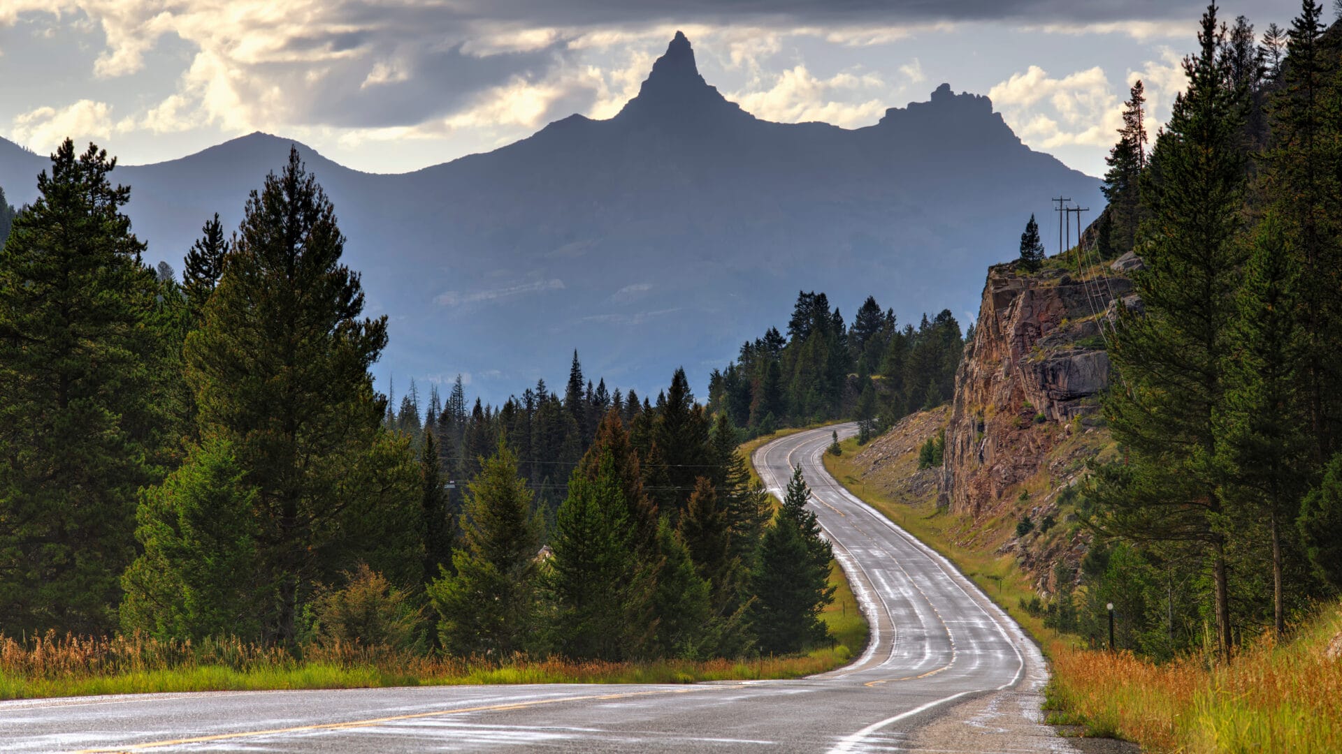
Pilot and Index Peaks (Yellowstone) Overlook
Vaguely reminiscent of the Matterhorn, the 11,699-foot Pilot Peak is half of a pair of prominent mountains visible from this overlook. The other is the more squatty (at 10,709 feet, still impressively tall) Index Peak. Both are part of the Absaroka Range, which forms the eastern escarpment of the Yellowstone Plateau.
Wyoming Highway 296, the Chief Joseph Scenic Byway, starts (or ends, depending on your direction of travel) at the Beartooth Highway near Lake Creek and the historic L Bar T Ranch, an occasional haunt of Ernest Hemingway. Named for the chief of the Nez Perce tribe, who tried in vain to stay one step ahead of the U.S. Cavalry and lead his people to freedom in Canada, the 47-mile Chief Joseph Scenic Byway crosses the Shoshone National Forest as it heads south from Beartooth Highway, ending just outside of Cody, Wyoming. Highlights include views of the North Absaroka Mountains, Beartooth Mountains, Beartooth Plateau, the Clarks Fork of the Yellowstone River, and a transit of Dead Indian Pass.
Crazy Creek Falls and Campground
Crazy Creek Falls are more of a slide than a waterfall, with the waters of Crazy Creek plunging 120 feet down a slope of bedrock. A short trail leads to the falls from Crazy Creek Campground, which has 16 campsites overlooking Crazy Creek from a bluff. The campground, about 11 miles from Cooke City, is open May through September and has picnic tables, fire rings, and vault toilets, but no water.
Great views of Pilot and Index Peaks are included with stays at this 33-site campground, open to both tent and trailer campers and featuring picnic tables, fire rings, vault toilets, and potable water. Several sites have electric hookups.
This picnic area 4 miles east of Cooke City has three riverside picnic tables and also serves as a trailhead for hikes into the Custer Gallatin National Forest via the Russell Creek Trail, a 26-mile point-to-point trail also known as The Beaten Path.
Founded in 1933, the Skyline Guest Ranch offers lodge accommodations and glamping along with camping, horseback riding, and guided fishing expeditions. Look for the wagon pointing the way to the lodge on the side of Beartooth Highway at Kersey Lake Road, 3 miles east of Cooke City.
A campground for hard-sided camping only, the Custer Gallatin National Forest’s Colter Campground has 18 sites with fire grates, picnic tables, toilets, and potable water. Open July through September, the access road is not suitable for vehicles longer than 48 feet.
Like Colter, Soda Butte Campground is limited to hard-sided camping (no tents) and has identical amenities, operating season, and vehicle restrictions. There are 27 campsites at this campground located just a mile east of Cooke City.
The “Coolest Small Town in America” is perfectly positioned for exploring the Beartooth Highway, which runs east of town; Yellowstone National Park, just to the west; or both. The year-round population barely tops 100 people, but Cooke City stays lively both summer and winter between accommodating Yellowstone visitors and organizing activities from fishing to snowmobiling. Visitor services include lodging, gas stations, shopping, and outfitters and guide services. Dining options include the historic Antler Lodge and Miners Saloon.
Beartooth Highway FAQs
Where does the Beartooth Highway begin and end?
The Beartooth Highway is a section of U.S. Route 212 running between Cooke City and Red Lodge, Montana, although it dips into the state of Wyoming along the way. Cooke City is also the northeast entrance to Yellowstone National Park.
How long does it take to drive the Beartooth Highway?
If you just want to enjoy the drive, you can make it from Red Lodge to Cooke City in about 2 hours. The speed limit on what’s been dubbed “the most beautiful road in America” is set as high as 80 mph in some sections. It’s much better, however, to slow things down and take a few days to explore.
How much does the Beartooth Highway cost, and do park fees apply?
There is no cost to drive the Beartooth Highway. However, the 7-day entrance fee for Yellowstone National Park is $35 per private vehicle, including RVs.
How many miles is the Beartooth Highway?
The Beartooth Highway is 68.7 miles long.
What is the best way to travel the Beartooth Highway?
The Beartooth Highway can be driven by car, RV, or motorcycle. Bicyclists also sometimes share the road, enduring thousands of feet of elevation gain during the climb to Beartooth Pass from either direction.
What is the best time of year to drive the Beartooth Highway?
Heavy snowfall in the Beartooth Pass keeps the Beartooth Highway closed in winter. The road is generally open from the Friday of Memorial Day weekend (late May) through mid-September, so that’s your best option for driving the entire length of the highway
What are the driving conditions on the Beartooth Highway?
The driving conditions on the Beartooth Highway vary. The road includes both a high-speed segment through flatlands in Montana and steep, twisting climbs and descents through the 10,947-foot Beartooth Pass in Wyoming. Cautious driving is required on both the slower and faster sections of the road, and mountain switchbacks can be challenging for less-experienced RV drivers. The road is closed from early fall to late spring.
Is it better to drive the Beartooth Highway east to west?
The Beartooth Highway can be driven in either direction. Some people do the drive west to east as an extension of a visit to Yellowstone National Park, while others use Red Lodge and the Beartooth Highway as a gateway to the park.
Are there bathrooms on the Beartooth Highway?
Restrooms can be found at the Rock Creek Vista Point Rest Area and Interpretive Trail, the Top of the World store in Beartooth Pass, at National Forest campgrounds, and in the towns of Cooke City and Red Lodge.