A simple 3-day Pacific Coast Highway road trip that still works with the Big Sur closure, with clear stops and one easy inland shortcut.
Key takeaways:
- The trip is about 300 miles total, spread over 3 days (assuming you’re driving 3–5 hours each day).
- Spring and fall are the best seasons for clearer skies, wildflowers, and lighter traffic.
- One scenic inland road, Carmel Valley Road (G16), takes you back to Highway 101 and the Bay Area.
Further reading...

What this 3-day loop actually is
This is a short Pacific Coast Highway road trip that starts in the San Francisco Bay Area, follows Highway 1 down the coast, turns around in Big Sur, then returns inland on Carmel Valley Road.
It’s built for current road conditions: you still see Big Sur, but you don’t get stuck at a “Road Closed” sign and waste a day backtracking.
It works well for:
- first-time visitors who want famous views without a full SF–LA drive
- locals who want a long weekend
- photographers who care about sunrise and sunset spots
Route at a glance
If you only have a long weekend, this loop gives you the best of a Pacific Coast Highway road trip without a long SF–LA haul. Here’s the big picture of where you’ll go and how each day fits together.
- Start / finish: San Francisco → Slow Coast (Pescadero / Davenport) → Big Sur → Carmel Valley → Highway 101 → back to the Bay Area
- Distance / time: Around 300 miles over 3 days
- Driving style: Curvy cliff road on Highway 1, then quieter farm and hill roads on the way back
- Map idea: Roadtrippers trip with pins at Pescadero, Pigeon Point, Davenport, Carmel, Point Lobos, Bixby Bridge, Pfeiffer Beach, McWay Falls, Partington Cove, Carmel Valley Village, Greenfield
Now let’s break it into days, starting with the Slow Coast stretch from San Francisco down to Pescadero and Davenport.
Day 1 – “Slow Coast” from San Francisco to Davenport
Today is about short drives, small towns, and easy ocean views. You don’t need to rush.
1. Devil’s Slide Trail
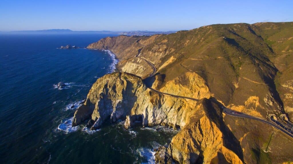
Just south of Pacifica, the old cliff road is now a paved walking and bike path.
- Big ocean views with no cars
- A worn WWII bunker on the hill is a fun photo stop
- Parking lots at each end; they fill on sunny weekends, so mornings are best
2. Pescadero: soup and bread stop
Turn inland on Pescadero Creek Road. The town is small and walkable.
- Duarte’s Tavern: famous artichoke and green chile soup, plus berry pie
- Arcangeli (Norm’s Market): warm artichoke-garlic bread, cheese, and snacks for later on the trip
3. Pigeon Point Lighthouse
Back on Highway 1, stop at the tall white lighthouse.
- Good whale-watching spot in spring
- Short paths along the bluff
- Simple bathroom and picnic tables
4. Swanton Berry Farm and Shark Fin Cove
Near Davenport, Swanton Berry Farm sells organic berries and baked goods. You pay at the counter or on the honor system.
Less than a mile south is Shark Fin Cove, with a huge rock in the water that really looks like a fin.
- Best at sunset
- Steep, rough path down; wear real shoes
- At low tide, you can explore the beach and sea cave
Where to sleep (Night 1)
- Costanoa (near Pescadero): cabins and canvas “tents” with real beds, plus a restaurant and hot tubs. Cabins are drier and quieter than canvas units.
- Budget option: Pigeon Point Hostel in the lighthouse buildings (simple rooms, wild views).
Day 2 – Big Sur out-and-back
This is the core of the trip. You will drive south through Big Sur, turn around near McWay Falls, then come back north.
Morning in Carmel-by-the-Sea
Grab coffee and walk a bit in town, then head to Carmel Meadows/Ribera Road for a quieter coastal path with views toward Point Lobos.
1. Point Lobos State Natural Reserve
Just south of Carmel, this small park has coves, cypress trees, and sea lions.
- Best plan: Arrive near opening time. The lot often fills by 9 a.m.
- Short walk: Bird Island Trail to China Cove, with bright green water and good wildlife viewing from above
There is a state park day-use fee per car.
2. Garrapata State Park and Calla Lily Valley
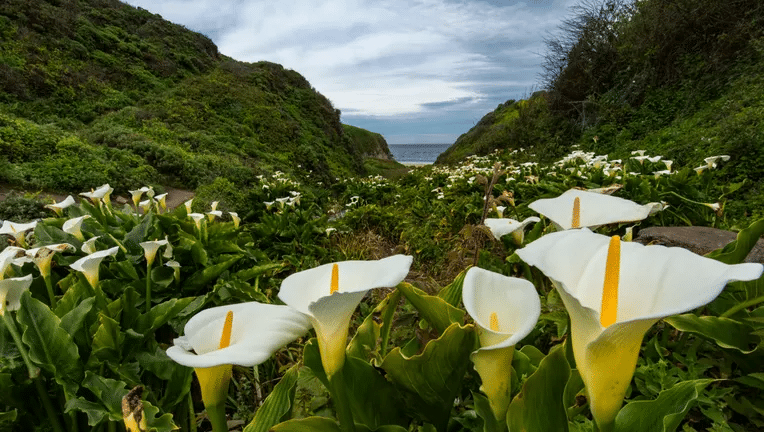
Continue south on Highway 1. There’s no big entrance sign, just small turnouts.
- In late winter and early spring, a ravine near mile marker 63 fills with wild calla lilies
- Short but steep path; can be muddy after rain
3. Rocky Creek Bridge and Bixby Creek Bridge
Two classic concrete bridges span deep canyons.
- Rocky Creek Bridge: smaller and often empty, good for a quick stop
- Bixby Creek Bridge: the famous one. Skip the crowded ocean-side turnout and turn up Old Coast Road instead for a higher view back toward the bridge and ocean.
4. Pfeiffer Beach
Look for Sycamore Canyon Road (a narrow side road without big signs).
- Purple streaks in the sand after storms
- A rock arch just offshore; around late December and early January the sun sets through the arch
- Road is one lane in places with tight pullouts; big RVs are not a great match here
5. McWay Falls and Partington Cove (turnaround point)
Highway 1 is closed farther south at Regent’s Slide, so this is where you stop and head back.
- McWay Falls: 80-foot waterfall dropping to the beach in Julia Pfeiffer Burns State Park. The main overlook trail is closed right now, but you can see the falls from roadside pullouts.
- Partington Cove: Two miles north. Short, steep walk down a road, across a bridge, and through a tunnel to a rocky cove that feels hidden and quiet.
Food stops in Big Sur
- Nepenthe: cliff-top restaurant with sweeping views and a simple burger menu.
- Big Sur Bakery or Deetjen’s: cozy spots for coffee, pastries, and dinner.
Where to sleep (Night 2)
- Ventana Big Sur glamping: safari tents with real beds and a nice bathhouse in the redwoods.
- Carmel-by-the-Sea: many small inns if you prefer a town base and shorter drives.
Note: Treebones Resort is on the south side of the slide and not part of this loop right now.
Curious what you’re missing? Check out our deep dive into the resort’s wild, open-air “Human Nest”.
Day 3 – Carmel Valley Road and the inland shortcut
Instead of re-driving Highway 1 all the way north, locals often cut inland on Carmel Valley Road (G16).
1. Carmel Valley and Garland Ranch

From Highway 1, head east into Carmel Valley. The road starts wide, with vineyards and tasting rooms.
Stop at Garland Ranch Regional Park near the start of the valley.
- Easy riverside trails
- Shade and fall color in season
2. Carmel Valley Village
Further east, the village has clusters of tasting rooms and patios.
Popular stops:
- Folktale Winery
- Georis Winery
- Cowgirl Winery
Pick one for lunch; make sure only one person in your group is drinking if you’re driving.
3. The twisty section and Salinas Valley
After the village, Carmel Valley Road narrows and climbs into the hills.
- Many curves, few guardrails, and almost no shoulder
- Deer are common near dusk; locals avoid driving it after dark if they can
The road then drops into Salinas Valley, with big farm fields on both sides. From Greenfield, join Highway 101 north for a fast, two-hour run back toward the Bay Area.
Best time to go
You can drive this loop all year, but it feels different in each season.
- January–April: Green hills, wildflowers, and calla lilies at Garrapata. More rain, and a higher chance of small slides or short closures.
- May–June: Good mix of sun and light fog. Gray whales are still possible off Pigeon Point.
- July–August: Expect more fog, especially in the mornings (“June gloom” often runs into summer). This is also the busiest time on Highway 1.
- September–October: Often the clearest skies and warmest afternoons, with smaller crowds once school is back in session.
- November–mid-January: Short days and stronger storms, but the sunset light at Pfeiffer Beach is at its best.
Rules, fees, and basic logistics
Before you head out, there are a few practical things to know about this Pacific Coast Highway road trip. These basics around park fees, pets, gas, and cell service will help you avoid surprises on the road.
- Park fees: State parks like Point Lobos and Julia Pfeiffer Burns charge a per-vehicle day-use fee. Have cash or a card ready.
- Dogs: Many trails do not allow dogs, but some beaches and roadside stops do. Check each park’s rules.
- Fuel and food: Fill up in bigger towns (Pacifica, Half Moon Bay, Santa Cruz, Carmel, or Monterey). Gas is limited and more expensive in Big Sur.
- Cell service: Expect long stretches with no signal between Santa Cruz and Big Sur. Download maps and your Roadtrippers route before you go.
Safety and closures
This loop is built around the current Highway 1 closure at Regent’s Slide south of Big Sur. That section is expected to stay closed into 2026.
A few simple rules keep things low-stress:
- Check Highway 1 status on the Caltrans site before you go
- Drive slowly on narrow roads like Sycamore Canyon Road and Carmel Valley Road
- Watch for deer on G16 at dawn and dusk
- Avoid driving the twisty inland section at night if you can
Frequently asked questions
Three days is enough to see the Slow Coast, Big Sur, and Carmel Valley without feeling rushed. If you want more beach time or hikes, add one extra night in Big Sur or Carmel.
Small campervans and short Class C RVs can handle most of it in good weather. Skip the side road to Pfeiffer Beach and think twice about Carmel Valley Road if you’re in a larger rig.
Yes, but your pattern changes. Many people from LA build a “Southern Loop” around Cambria, Cayucos, Ragged Point, and the south side of Big Sur, plus Highway 101.
You can keep this 3-day loop and simply connect the middle day to a longer SF–LA or LA–SF drive. The Slow Coast and Carmel Valley Road are still worth it even when the road is fully open.
Yes, if they handle curvy roads. Build in short walks at Devil’s Slide, Pescadero, and Point Lobos, and plan snack stops in Carmel and Big Sur.
Plan this Pacific Coast Highway road trip in Roadtrippers
Set up this 3-day Pacific Coast Highway road trip as a loop: add your Devil’s Slide, Slow Coast, Big Sur, and Carmel Valley stops, then download the map for offline use so you’re covered when cell service drops. You can save the trip, share it with friends, and tweak your stops as road conditions change.
Meet the Author