Detours help you find lesser-known places to visit all over the U.S.
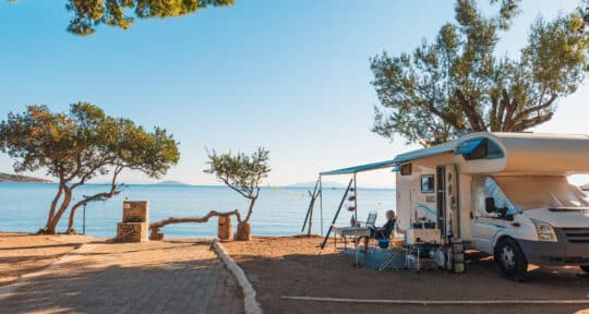
Heading out on Kate Courtney’s mountain bike road trip? Use this guide to discover hidden gems along the way.
Whether you’re taking world mountain bike champion Kate Courtney’s perfect mountain bike road trip or not, there’s a lot to discover in between the stunning Sierra Nevada mountains, lush forests of the Pacific Northwest, and Red Rocks of Southern Utah. There’s nothing quite like exploring the West’s scenic landscape on a mountain bike. The region has so much to discover when you’re not in the saddle. To prove that point, here are some of Roadtrippers’ favorite detours through the Western U.S.
Further reading...

Mount Tamalpais State Park to Downieville, California
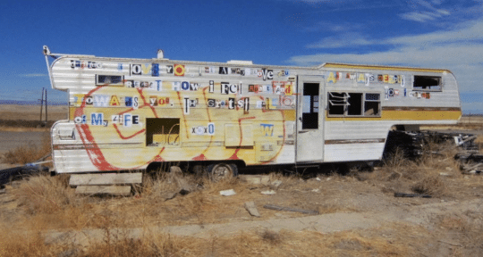
Detour 1: Big House Prison Museum
In between Mount Tam and Downieville is the Big House Prison Museum, a roadside gem. Formerly the Folsom Prison Museum, the museum contains a wealth of information. Displays highlight the unique history at this old prison; you can see some dark artifacts like rope used to hang inmates, restraint devices such as a vintage ball-and-chain, and shivs that were hand-fashioned by prisoners.
On the lighter side of things, there’s an impressive eight-foot motorized Ferris fashioned from toothpicks by a prisoner in the 1930s, license plates pressed by inmates, and—of course—plenty of memorabilia from Johnny Cash’s famous concerts here. The museum isn’t huge, but it’s jam-packed with history. The whole vibe is enhanced by the fact that it’s on the grounds of an active prison, just outside the East Gate.
Downieville, California to Lake Tahoe, California
Detour 2: Donner Pass
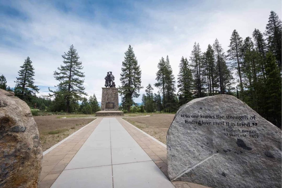
As you drive from Downieville to Tahoe, you’ll be in an area that was once traveled by pioneers heading across the country in search of new lives in Oregon and California. Donner Pass is named for The Donner Party. Due to a series of ill-fated missteps, the party arrived here in November of 1846 and found the pass already blocked by snow.
The pioneers were forced to spend a long and brutal winter on the east side of the pass, at what is now known as Donner Lake. 34 pioneers in the party died that winter, and those who did survive famously resorted to cannibalism. Today, the pass is quite easy to travel, as the scenic Northern Alternate Lincoln Highway crosses Donner Pass. Alternately, I-80 crosses the Sierra Nevada at what is sometimes called “Donner Summit.” To get more in-depth on this slice of Westward Expansion history, stop by Donner Memorial State Park.
Lake Tahoe, California to Bend, Oregon
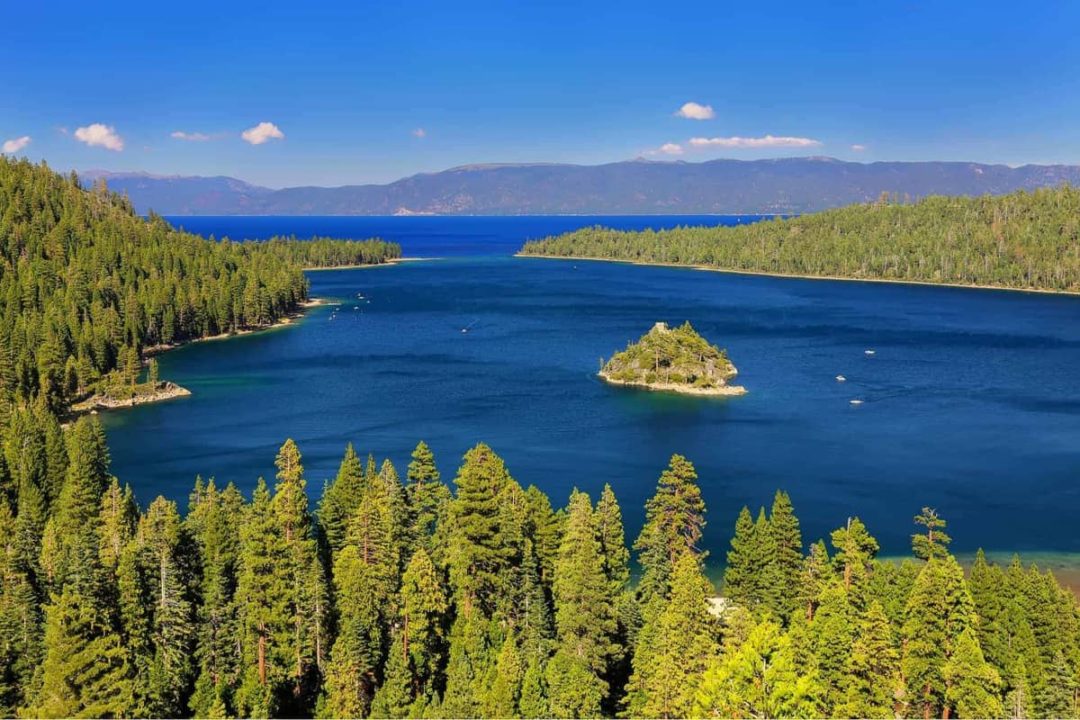
Detour 3: Fannette Island
One of the coolest hidden gems of Lake Tahoe is the abandoned building on Fannette Island. It looks a bit spooky, but it’s actually a tea house. Well, really, it’s an unused chapel/tomb turned tea house. The structure was originally built by Captain Dick “Them’s My Toes” Barter. He was an eccentric, yet reclusive English sailor who was famous for showing off his self-amputated toes. Captain Dick planned to be buried in the building.Since he was lost at sea—or lost at lake, if you will—off Tahoe’s Rubicon Point in 1873, he couldn’t exactly be buried here. The stone structure was then snapped up by the wealthy Mrs. Lora Josephine Knight. Mrs. Knight is best known for constructing Vikingsholm, a Scandinavian-inspired castle on the shores of Lake Tahoe in 1928—it’s still standing today, and is open for tours. She’s the one who turned the building on Fannette Island into a tea house; she would take friends out here on a motorboat.
Today, you can kayak, paddle board, or boat out to the island from Emerald Bay and explore it for yourself. Just don’t plan on swimming over, since it’s not allowed … it’s too cold and too dangerous due to boat traffic.
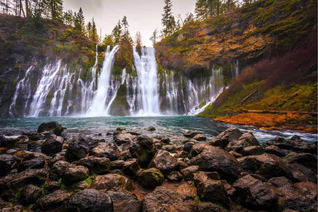
Detour 4: McArthur-Burney Falls Memorial State Park
As you leave Tahoe and head north for Oregon, you’ll pass by some unreal natural beauty. Lassen Volcanic National Park is one great place to stop and explore. It’s one of the few places on Earth where you can see all four types of volcano and has a lot of stunning geothermal features like mud pots, steam vents, geysers, and hot springs.
If you’re looking for something a bit less huge, though, stop by the popular McArthur-Burney Falls Memorial State Park. This is California’s second oldest state park.The main attraction is Burney Falls, right at the park’s entrance. The spring-fed cascade was declared by Theodore Roosevelt to be the “eighth wonder of the world,” and is a National Natural Landmark. The park offers some short hiking trails, water activities on Lake Britton and Burney Creek, interpretive programs, and more.
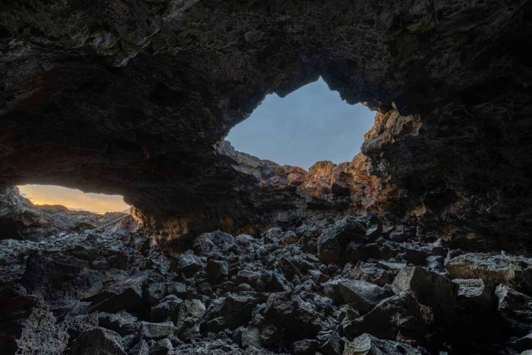
Detour 5: Lava Beds National Monument
Take your adventure underground at Lava Beds National Monument. Roughly twenty of the tubes are open to visitors.Each cave is totally different, meaning there’s something for every kind of visitor. Big Painted Cave, for example, has ancient Native American pictographs around the entrance, Golden Dome Cave has hydrophobic bacteria covering the ceiling, giving it a golden yellow hue, and Catacombs Cave is the lowest, twistiest, and longest cave in the park.
You can also sign up for guided tours of some of the more delicate caves. In the winter, you can visit the mesmerizing Crystal Ice Caves. Be forewarned: they’re definitely not for the inexperienced spelunker.
Bend, Oregon to Sun Valley, Idaho
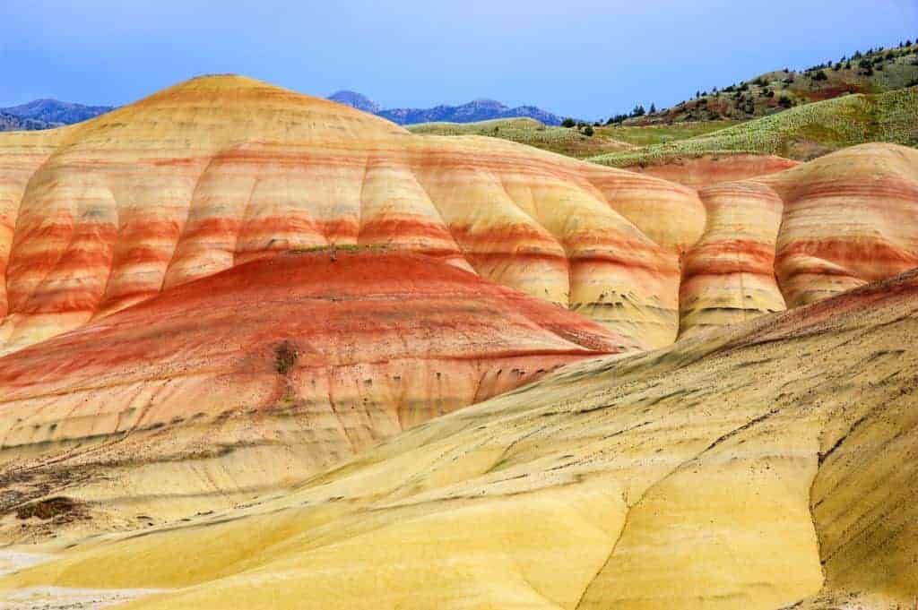
Detour 6: John Day Fossil Beds National Monument
John Day Fossil Beds National Monument is a geology enthusiast’s dream … albeit one anyone can enjoy. You can appreciate the stunning and colorful eroded rock formations and fossils for their aesthetic beauty or their scientific value, or both. The Monument is divided up into three spread out units: the Clarno Unit, the Painted Hills Unit and the Sheep Rock Unit. The Painted Hills are internet famous for the bright colors that appear to be splashed all across the rocks. Sheep Rock is a great starting place for those who haven’t explored the Monument since it’s home to the main visitor center and the Thomas Condon Paleontology Center, both of which provide valuable insight and background on the rich natural history in the area. All three units offer hikes loaded with interpretive signs and plenty of ranger-led programs to further add to the experience. And the best part? Admission to all of this is totally free.
Detour 7: Alvord Desert & Mann Lake
Detour a bit south to experience one of Oregon’s most unusual landscapes: the Alvord Desert. The cold, semi-arid climate makes for an unusual and totally unique stop. The twelve-by-seven-mile area gets fewer than seven inches of rain per year thanks to a mountainous rain shadow. It still experiences four solid seasons, with sometimes snowy winters, hot summers, and very damp springs. Alvord comes with its very own oasis in the form of Mann Lake, and you can find hot springs to soak in here as well. And, come summer, you can even try your hand at land sailing or just go for a drive—a women’s land speed record was set here in the 1970s. Still not convinced? The sunrises, sunsets, and stargazing in the desert are said to be some of the best in the state.
Detour 8: Kirkham Hot Springs
There’s no better break from the road than a soak in a hot spring. And Idaho has tons of geothermal relaxation to offer. Kirkham Hot Springs are undeveloped, so they have that natural atmosphere. However, they also are convenient to reach and have some amenities—like parking, vault toilets, a staircase down to the river, and campsites available nearby. Wade in the river to find soaking pools of varying temperatures and steamy waterfalls that can be used as a warm, natural shower. It can get a bit crowded in the summer months, but it’s quite secluded in the winter. Pro tip: Highway 21, which runs alongside these springs, is actually lined with hot spring sites perfect for a relaxing dip.
Between Sun Valley, Idaho and Moab, Utah
Detour 9: Craters of the Moon National Monument
Forged from the lava and ash of thousands of years of volcanic activity, Craters of the Moon National Monument is a spot that’s invented its own kind of natural beauty. Here you’ll find the remains of more than 25 volcanic cones and 60 ancient lava flows. Eruptions at Craters of the Moon occurred between 15,000 and 2,000 years ago. That means that Native American tribes, like the Shoshone, likely witnessed some of the later eruptions.
It wasn’t until the early 20th century that people started to explore the area. In the 1920s, Calvin Coolidge proclaimed in a National Monument in order to “preserve the unusual and weird volcanic formations” (yes, he actually called this place “weird”).
Because of its weird geologic history, there’s plenty to do here. You can see purple-blue obsidian embedded in the North Crater Flow, explore the Devil’s Orchard (a collection of cinder cone fragments), hike to the top of Inferno Cone, look at the tree molds (formed when the bark of ancient trees left prints in lava), camp out, cruise Loop Drive through the stark landscape, and spend a few hours exploring the lava tubes in the cave area.
Detour 10: Experimental Breeder Reactor-1 Museum
The world’s first nuclear power plant, Idaho’s Experimental Breeder Reactor-1, is still standing and open for tours—despite the fact that it suffered a partial meltdown in 1955. This is the site where nuclear energy was harvested for the first time in history. On December 20 of 1951, four 200-Watt light bulbs were illuminated using nuclear power. The next day, the reactor was used to light the whole building.
This reactor wasn’t in use for very long; it was decommissioned in 1963, when it was replaced by the bigger and badder Experimental Breeder Reactor-II. EBR-I was quickly declared a National Historic Landmark and opened for tours in the 1970s. Displays in the free museum include the reactor control room, remote handling devices for the radioactive materials, vintage radiation detection equipment, and four nuclear reactors—two of which are prototypes for nuclear propulsion for aircraft.
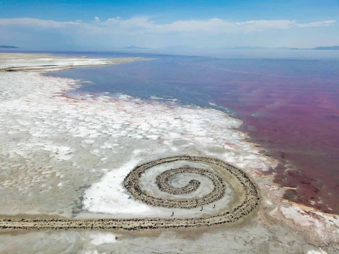
Detour 11: Spiral Jetty
On the Great Salt Lake’s northeastern shore lies the massive Spiral Jetty. The 1,500-foot-long, 15-foot-wide coil is made of 6,500 tons of basalt, earth, and salt. It’s the most famous work by renowned artist Robert Smithson, who remains particularly known for his land art and theoretical essays. He chose the site for the jetty because of the striking red color of the water—this part of the lake is especially saline and the red hue comes from algae and bacteria that flourish in that environment. He also liked the “stark anti-pastoral beauty” and industrial surroundings. Spiral Jetty was completed in April of 1970, and can still be seen today. Check the levels of the lake before you visit; if the water is high, the jetty might be submerged and harder to see.
Detour 12: Alpine Loop Scenic Byway
The Alpine Loop Scenic Byway is a windy, narrow, and utterly stunning route through the Uinta-Wasatch-Cache National Forest. The 20-mile cruise is most popular in the autumn because of its brilliant foliage. The views of Mt. Timpanogos are incredible year round, though. Along the way, you’ll pass by the famed Sundance Mountain Resort, Timpanogos Cave National Monument (home to three caves loaded with helictites, cave bacon, flowstone, cave popcorn, drapery, stalactites, stalagmites, and other unique features) and Cascade Springs, where boardwalks wind over crystal clear spring-fed ponds.
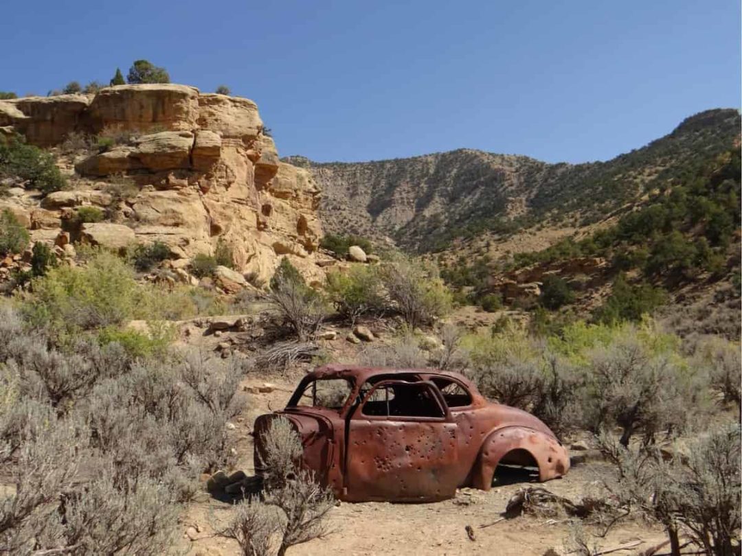
Detour 13: Ghost Town of Sego
Sego—or the Ballard-Sego Coal Mine Historic District if we’re being formal—is a perfect example of a classic Western mining ghost town.The name Sego was eventually chosen as a tribute to the sego lily, Utah’s state flower. The town lasted for only a short while, from 1910 to 1955, and its population topped out at around 200 citizens in the 1930s.
The local Chesterfield Coal Company shut down in 1947, and the railroad into town was abandoned in 1950. Scarce water, fire, and flash floods had also plagued the town throughout its history. Some buildings, like the company store, remain standing.And the collapsed wooden remains and dug out foundations of others can be seen as well. And if you happen to see smoke billowing from abandoned mine shafts while you visit, that’s from an underground coal seam fire that has burned here for decades.
Meet the Author
- Related Articles
- Latest Articles